You are here: Home > Network List > US - United States National Seismic Network Stations List
> Station MNTX Cornudas Mountains, Texas, USA > Earthquake Result Viewer
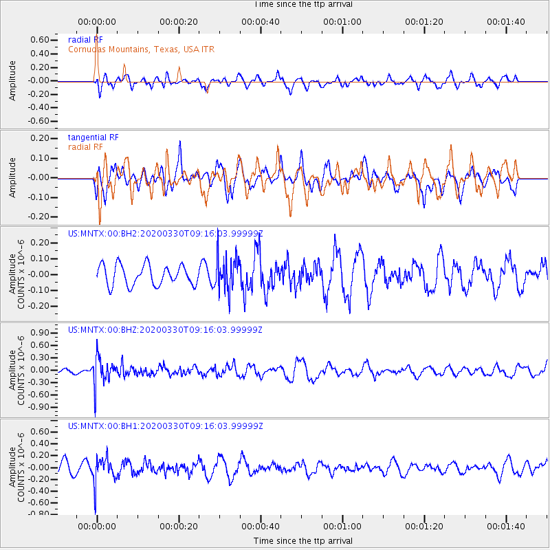
MNTX Cornudas Mountains, Texas, USA - Earthquake Result Viewer
*The percent match for this event was below the threshold and hence no stack was calculated.
| Earthquake location: |
Colombia-Ecuador Border Region |
| Earthquake latitude/longitude: |
0.3/-77.7 |
| Earthquake time(UTC): |
2020/03/30 (090) 09:09:05 GMT |
| Earthquake Depth: |
128 km |
| Earthquake Magnitude: |
5.2 Mww |
| Earthquake Catalog/Contributor: |
NEIC PDE/us |
|
| Network: |
US United States National Seismic Network |
| Station: |
MNTX Cornudas Mountains, Texas, USA |
| Lat/Lon: |
31.70 N/105.38 W |
| Elevation: |
404 m |
|
| Distance: |
40.8 deg |
| Az: |
322.644 deg |
| Baz: |
134.617 deg |
| Ray Param: |
$rayparam |
*The percent match for this event was below the threshold and hence was not used in the summary stack. |
|
| Radial Match: |
40.523174 % |
| Radial Bump: |
400 |
| Transverse Match: |
45.459946 % |
| Transverse Bump: |
394 |
| SOD ConfigId: |
20906531 |
| Insert Time: |
2020-04-13 09:29:38.598 +0000 |
| GWidth: |
2.5 |
| Max Bumps: |
400 |
| Tol: |
0.001 |
|
Signal To Noise
| Channel | StoN | STA | LTA |
| US:MNTX:00:BHZ:20200330T09:16:03.99999Z | 4.110052 | 3.3087895E-7 | 8.050481E-8 |
| US:MNTX:00:BH1:20200330T09:16:03.99999Z | 2.2416334 | 2.2114104E-7 | 9.865174E-8 |
| US:MNTX:00:BH2:20200330T09:16:03.99999Z | 1.7100114 | 1.0899479E-7 | 6.373922E-8 |
| Arrivals |
| Ps | |
| PpPs | |
| PsPs/PpSs | |


