You are here: Home > Network List > UW - Pacific Northwest Regional Seismic Network Stations List
> Station UMAT Pilot Rock, OR, USA > Earthquake Result Viewer
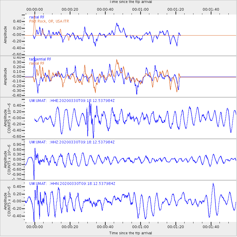
UMAT Pilot Rock, OR, USA - Earthquake Result Viewer
*The percent match for this event was below the threshold and hence no stack was calculated.
| Earthquake location: |
Colombia-Ecuador Border Region |
| Earthquake latitude/longitude: |
0.3/-77.7 |
| Earthquake time(UTC): |
2020/03/30 (090) 09:09:05 GMT |
| Earthquake Depth: |
128 km |
| Earthquake Magnitude: |
5.2 Mww |
| Earthquake Catalog/Contributor: |
NEIC PDE/us |
|
| Network: |
UW Pacific Northwest Regional Seismic Network |
| Station: |
UMAT Pilot Rock, OR, USA |
| Lat/Lon: |
45.29 N/118.96 W |
| Elevation: |
1318 m |
|
| Distance: |
57.7 deg |
| Az: |
326.577 deg |
| Baz: |
128.712 deg |
| Ray Param: |
$rayparam |
*The percent match for this event was below the threshold and hence was not used in the summary stack. |
|
| Radial Match: |
47.349483 % |
| Radial Bump: |
400 |
| Transverse Match: |
58.17586 % |
| Transverse Bump: |
400 |
| SOD ConfigId: |
20906531 |
| Insert Time: |
2020-04-13 09:31:20.519 +0000 |
| GWidth: |
2.5 |
| Max Bumps: |
400 |
| Tol: |
0.001 |
|
Signal To Noise
| Channel | StoN | STA | LTA |
| UW:UMAT: :HHZ:20200330T09:18:12.537984Z | 2.2377238 | 3.5172363E-7 | 1.5717919E-7 |
| UW:UMAT: :HHN:20200330T09:18:12.537984Z | 1.5598855 | 2.4391952E-7 | 1.5637013E-7 |
| UW:UMAT: :HHE:20200330T09:18:12.537984Z | 1.5079211 | 2.9724953E-7 | 1.9712539E-7 |
| Arrivals |
| Ps | |
| PpPs | |
| PsPs/PpSs | |


