You are here: Home > Network List > AV - Alaska Volcano Observatory Stations List
> Station GSIG Igitkin Island, Great Sitkin Volcano, Alaska > Earthquake Result Viewer
GSIG Igitkin Island, Great Sitkin Volcano, Alaska - Earthquake Result Viewer
| Earthquake location: |
Western Idaho |
| Earthquake latitude/longitude: |
44.5/-115.1 |
| Earthquake time(UTC): |
2020/03/31 (091) 23:52:30 GMT |
| Earthquake Depth: |
10 km |
| Earthquake Magnitude: |
6.8 Ml |
| Earthquake Catalog/Contributor: |
NEIC PDE/us |
|
| Network: |
AV Alaska Volcano Observatory |
| Station: |
GSIG Igitkin Island, Great Sitkin Volcano, Alaska |
| Lat/Lon: |
51.99 N/175.93 W |
| Elevation: |
407 m |
|
| Distance: |
40.1 deg |
| Az: |
303.088 deg |
| Baz: |
75.844 deg |
| Ray Param: |
0.074576035 |
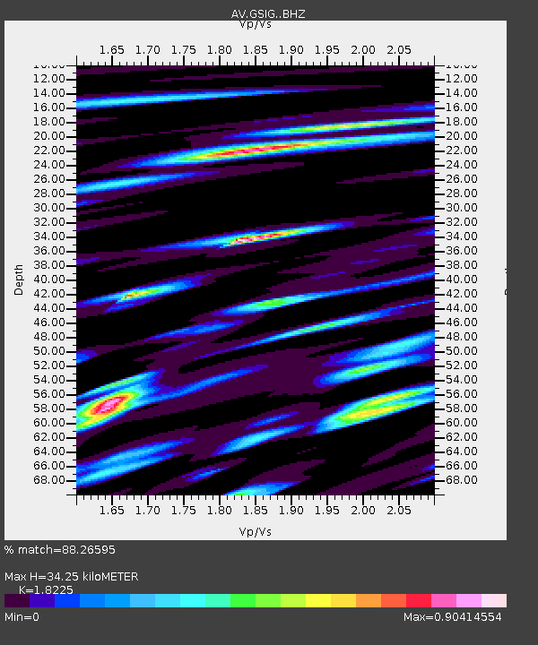
| Estimated Moho Depth: |
34.25 km |
| Estimated Crust Vp/Vs: |
1.82 |
| Assumed Crust Vp: |
3.943 km/s |
| Estimated Crust Vs: |
2.164 km/s |
| Estimated Crust Poisson's Ratio: |
0.28 |
|
| Radial Match: |
88.26595 % |
| Radial Bump: |
355 |
| Transverse Match: |
52.437798 % |
| Transverse Bump: |
400 |
| SOD ConfigId: |
21144311 |
| Insert Time: |
2020-04-14 23:53:04.824 +0000 |
| GWidth: |
2.5 |
| Max Bumps: |
400 |
| Tol: |
0.001 |
|
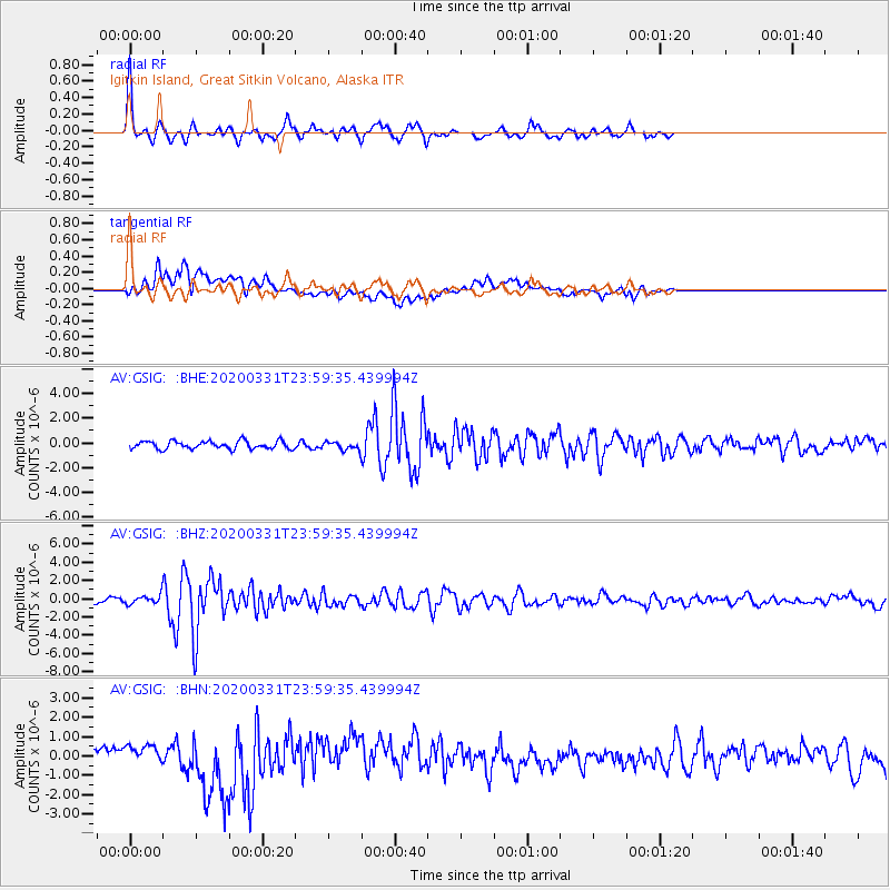
Signal To Noise
| Channel | StoN | STA | LTA |
| AV:GSIG: :BHZ:20200331T23:59:35.439994Z | 1.6166527 | 4.5361986E-7 | 2.8059202E-7 |
| AV:GSIG: :BHN:20200331T23:59:35.439994Z | 1.6970775 | 4.2488776E-7 | 2.5036437E-7 |
| AV:GSIG: :BHE:20200331T23:59:35.439994Z | 0.9505424 | 3.0014053E-7 | 3.1575712E-7 |
| Arrivals |
| Ps | 7.3 SECOND |
| PpPs | 24 SECOND |
| PsPs/PpSs | 31 SECOND |


