You are here: Home > Network List > AV - Alaska Volcano Observatory Stations List
> Station TAFP Falls Point, Tanaga Volcano, Alaska > Earthquake Result Viewer
TAFP Falls Point, Tanaga Volcano, Alaska - Earthquake Result Viewer
| Earthquake location: |
Western Idaho |
| Earthquake latitude/longitude: |
44.5/-115.1 |
| Earthquake time(UTC): |
2020/03/31 (091) 23:52:30 GMT |
| Earthquake Depth: |
10 km |
| Earthquake Magnitude: |
6.8 Ml |
| Earthquake Catalog/Contributor: |
NEIC PDE/us |
|
| Network: |
AV Alaska Volcano Observatory |
| Station: |
TAFP Falls Point, Tanaga Volcano, Alaska |
| Lat/Lon: |
51.90 N/177.99 W |
| Elevation: |
440 m |
|
| Distance: |
41.4 deg |
| Az: |
303.459 deg |
| Baz: |
74.508 deg |
| Ray Param: |
0.07383487 |
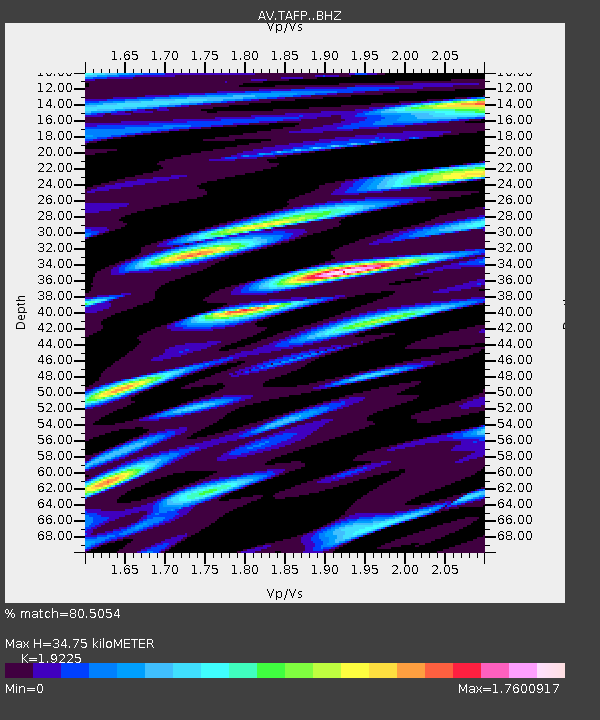
| Estimated Moho Depth: |
34.75 km |
| Estimated Crust Vp/Vs: |
1.92 |
| Assumed Crust Vp: |
5.88 km/s |
| Estimated Crust Vs: |
3.059 km/s |
| Estimated Crust Poisson's Ratio: |
0.31 |
|
| Radial Match: |
80.5054 % |
| Radial Bump: |
400 |
| Transverse Match: |
64.56394 % |
| Transverse Bump: |
400 |
| SOD ConfigId: |
21144311 |
| Insert Time: |
2020-04-14 23:53:20.013 +0000 |
| GWidth: |
2.5 |
| Max Bumps: |
400 |
| Tol: |
0.001 |
|

Signal To Noise
| Channel | StoN | STA | LTA |
| AV:TAFP: :BHZ:20200331T23:59:45.779013Z | 2.896489 | 8.766858E-7 | 3.026719E-7 |
| AV:TAFP: :BHN:20200331T23:59:45.779013Z | 1.2141471 | 5.300861E-7 | 4.365913E-7 |
| AV:TAFP: :BHE:20200331T23:59:45.779013Z | 1.2650564 | 6.029365E-7 | 4.7660842E-7 |
| Arrivals |
| Ps | 5.7 SECOND |
| PpPs | 16 SECOND |
| PsPs/PpSs | 22 SECOND |


