You are here: Home > Network List > AV - Alaska Volcano Observatory Stations List
> Station TAPA Point Aries, Tanaga Volcano, Alaska > Earthquake Result Viewer
TAPA Point Aries, Tanaga Volcano, Alaska - Earthquake Result Viewer
| Earthquake location: |
Western Idaho |
| Earthquake latitude/longitude: |
44.5/-115.1 |
| Earthquake time(UTC): |
2020/03/31 (091) 23:52:30 GMT |
| Earthquake Depth: |
10 km |
| Earthquake Magnitude: |
6.8 Ml |
| Earthquake Catalog/Contributor: |
NEIC PDE/us |
|
| Network: |
AV Alaska Volcano Observatory |
| Station: |
TAPA Point Aries, Tanaga Volcano, Alaska |
| Lat/Lon: |
51.81 N/177.81 W |
| Elevation: |
640 m |
|
| Distance: |
41.3 deg |
| Az: |
303.293 deg |
| Baz: |
74.517 deg |
| Ray Param: |
0.07388454 |
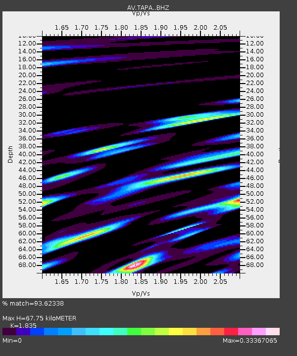
| Estimated Moho Depth: |
67.75 km |
| Estimated Crust Vp/Vs: |
1.84 |
| Assumed Crust Vp: |
5.88 km/s |
| Estimated Crust Vs: |
3.205 km/s |
| Estimated Crust Poisson's Ratio: |
0.29 |
|
| Radial Match: |
93.62338 % |
| Radial Bump: |
308 |
| Transverse Match: |
66.51172 % |
| Transverse Bump: |
400 |
| SOD ConfigId: |
21144311 |
| Insert Time: |
2020-04-14 23:53:21.296 +0000 |
| GWidth: |
2.5 |
| Max Bumps: |
400 |
| Tol: |
0.001 |
|

Signal To Noise
| Channel | StoN | STA | LTA |
| AV:TAPA: :BHZ:20200331T23:59:45.119986Z | 2.818901 | 8.6184286E-7 | 3.057372E-7 |
| AV:TAPA: :BHN:20200331T23:59:45.119986Z | 0.87224555 | 5.6045354E-7 | 6.42541E-7 |
| AV:TAPA: :BHE:20200331T23:59:45.119986Z | 2.488865 | 5.8250714E-7 | 2.340453E-7 |
| Arrivals |
| Ps | 10 SECOND |
| PpPs | 31 SECOND |
| PsPs/PpSs | 41 SECOND |


