You are here: Home > Network List > GS - US Geological Survey Networks Stations List
> Station PR03 PR03, Alturas Sabaneras > Earthquake Result Viewer
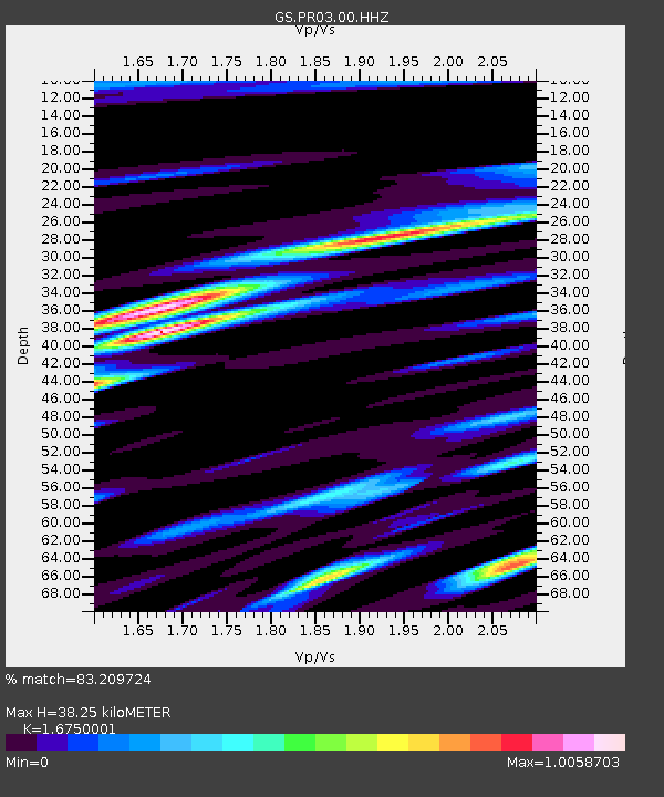
PR03 PR03, Alturas Sabaneras - Earthquake Result Viewer
| Earthquake location: |
Western Idaho |
| Earthquake latitude/longitude: |
44.5/-115.1 |
| Earthquake time(UTC): |
2020/03/31 (091) 23:52:30 GMT |
| Earthquake Depth: |
10 km |
| Earthquake Magnitude: |
6.8 Ml |
| Earthquake Catalog/Contributor: |
NEIC PDE/us |
|
| Network: |
GS US Geological Survey Networks |
| Station: |
PR03 PR03, Alturas Sabaneras |
| Lat/Lon: |
18.07 N/66.94 W |
| Elevation: |
113 m |
|
| Distance: |
48.0 deg |
| Az: |
107.416 deg |
| Baz: |
314.122 deg |
| Ray Param: |
0.06965899 |
| Estimated Moho Depth: |
38.25 km |
| Estimated Crust Vp/Vs: |
1.68 |
| Assumed Crust Vp: |
5.14 km/s |
| Estimated Crust Vs: |
3.069 km/s |
| Estimated Crust Poisson's Ratio: |
0.22 |
|
| Radial Match: |
83.209724 % |
| Radial Bump: |
400 |
| Transverse Match: |
76.80847 % |
| Transverse Bump: |
400 |
| SOD ConfigId: |
21144311 |
| Insert Time: |
2020-04-14 23:56:54.013 +0000 |
| GWidth: |
2.5 |
| Max Bumps: |
400 |
| Tol: |
0.001 |
|

Signal To Noise
| Channel | StoN | STA | LTA |
| GS:PR03:00:HHZ:20200401T00:00:38.468985Z | 9.764684 | 1.3505042E-6 | 1.3830497E-7 |
| GS:PR03:00:HH1:20200401T00:00:38.468985Z | 2.122725 | 4.3541252E-7 | 2.0511962E-7 |
| GS:PR03:00:HH2:20200401T00:00:38.468985Z | 2.3114512 | 3.8457432E-7 | 1.6637786E-7 |
| Arrivals |
| Ps | 5.2 SECOND |
| PpPs | 19 SECOND |
| PsPs/PpSs | 24 SECOND |


