You are here: Home > Network List > TS - TERRAscope (Southern California Seismic Network) Stations List
> Station RPV Rancho Palos Verde California, USA > Earthquake Result Viewer
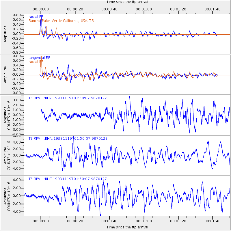
RPV Rancho Palos Verde California, USA - Earthquake Result Viewer
*The percent match for this event was below the threshold and hence no stack was calculated.
| Earthquake location: |
Unimak Island Region, Alaska |
| Earthquake latitude/longitude: |
54.3/-164.2 |
| Earthquake time(UTC): |
1993/11/19 (323) 01:43:23 GMT |
| Earthquake Depth: |
31 km |
| Earthquake Magnitude: |
6.2 MB, 6.3 MS |
| Earthquake Catalog/Contributor: |
WHDF/NEIC |
|
| Network: |
TS TERRAscope (Southern California Seismic Network) |
| Station: |
RPV Rancho Palos Verde California, USA |
| Lat/Lon: |
33.74 N/118.40 W |
| Elevation: |
115 m |
|
| Distance: |
37.9 deg |
| Az: |
103.775 deg |
| Baz: |
316.875 deg |
| Ray Param: |
$rayparam |
*The percent match for this event was below the threshold and hence was not used in the summary stack. |
|
| Radial Match: |
77.26911 % |
| Radial Bump: |
400 |
| Transverse Match: |
68.42045 % |
| Transverse Bump: |
400 |
| SOD ConfigId: |
4480 |
| Insert Time: |
2010-02-26 14:46:01.501 +0000 |
| GWidth: |
2.5 |
| Max Bumps: |
400 |
| Tol: |
0.001 |
|
Signal To Noise
| Channel | StoN | STA | LTA |
| TS:RPV: :BHN:19931119T01:50:07.987012Z | 2.8024127 | 8.174086E-7 | 2.916803E-7 |
| TS:RPV: :BHE:19931119T01:50:07.987012Z | 1.9003315 | 7.016196E-7 | 3.6920906E-7 |
| TS:RPV: :BHZ:19931119T01:50:07.987012Z | 0.58865047 | 3.0423678E-7 | 5.1683776E-7 |
| Arrivals |
| Ps | |
| PpPs | |
| PsPs/PpSs | |


