You are here: Home > Network List > TA - USArray Transportable Network (new EarthScope stations) Stations List
> Station B22K Teshekpuk Lake, AK, USA > Earthquake Result Viewer
B22K Teshekpuk Lake, AK, USA - Earthquake Result Viewer

| Earthquake location: |
Western Idaho |
| Earthquake latitude/longitude: |
44.5/-115.1 |
| Earthquake time(UTC): |
2020/03/31 (091) 23:52:30 GMT |
| Earthquake Depth: |
10 km |
| Earthquake Magnitude: |
6.8 Ml |
| Earthquake Catalog/Contributor: |
NEIC PDE/us |
|
| Network: |
TA USArray Transportable Network (new EarthScope stations) |
| Station: |
B22K Teshekpuk Lake, AK, USA |
| Lat/Lon: |
70.34 N/153.42 W |
| Elevation: |
50 m |
|
| Distance: |
32.1 deg |
| Az: |
336.738 deg |
| Baz: |
123.368 deg |
| Ray Param: |
0.07881864 |
| Estimated Moho Depth: |
20.25 km |
| Estimated Crust Vp/Vs: |
1.91 |
| Assumed Crust Vp: |
5.738 km/s |
| Estimated Crust Vs: |
3.008 km/s |
| Estimated Crust Poisson's Ratio: |
0.31 |
|
| Radial Match: |
83.52604 % |
| Radial Bump: |
400 |
| Transverse Match: |
78.91054 % |
| Transverse Bump: |
400 |
| SOD ConfigId: |
21144311 |
| Insert Time: |
2020-04-15 00:01:00.120 +0000 |
| GWidth: |
2.5 |
| Max Bumps: |
400 |
| Tol: |
0.001 |
|
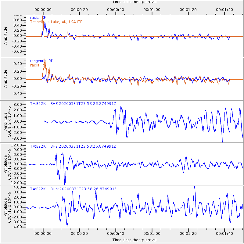
Signal To Noise
| Channel | StoN | STA | LTA |
| TA:B22K: :BHZ:20200331T23:58:26.874991Z | 2.2161565 | 2.4220643E-7 | 1.092912E-7 |
| TA:B22K: :BHN:20200331T23:58:26.874991Z | 0.6093916 | 1.00924616E-7 | 1.6561538E-7 |
| TA:B22K: :BHE:20200331T23:58:26.874991Z | 1.9048501 | 2.2537297E-7 | 1.1831533E-7 |
| Arrivals |
| Ps | 3.4 SECOND |
| PpPs | 9.7 SECOND |
| PsPs/PpSs | 13 SECOND |


