You are here: Home > Network List > TA - USArray Transportable Network (new EarthScope stations) Stations List
> Station F18K Selawik, AK, USA > Earthquake Result Viewer
F18K Selawik, AK, USA - Earthquake Result Viewer
| Earthquake location: |
Western Idaho |
| Earthquake latitude/longitude: |
44.5/-115.1 |
| Earthquake time(UTC): |
2020/03/31 (091) 23:52:30 GMT |
| Earthquake Depth: |
10 km |
| Earthquake Magnitude: |
6.8 Ml |
| Earthquake Catalog/Contributor: |
NEIC PDE/us |
|
| Network: |
TA USArray Transportable Network (new EarthScope stations) |
| Station: |
F18K Selawik, AK, USA |
| Lat/Lon: |
66.60 N/159.65 W |
| Elevation: |
27 m |
|
| Distance: |
32.4 deg |
| Az: |
328.512 deg |
| Baz: |
110.612 deg |
| Ray Param: |
0.07866885 |
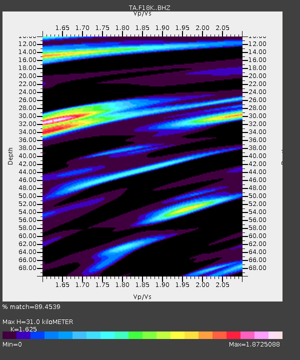
| Estimated Moho Depth: |
31.0 km |
| Estimated Crust Vp/Vs: |
1.62 |
| Assumed Crust Vp: |
6.577 km/s |
| Estimated Crust Vs: |
4.047 km/s |
| Estimated Crust Poisson's Ratio: |
0.20 |
|
| Radial Match: |
89.4539 % |
| Radial Bump: |
400 |
| Transverse Match: |
83.08004 % |
| Transverse Bump: |
383 |
| SOD ConfigId: |
21144311 |
| Insert Time: |
2020-04-15 00:01:18.968 +0000 |
| GWidth: |
2.5 |
| Max Bumps: |
400 |
| Tol: |
0.001 |
|

Signal To Noise
| Channel | StoN | STA | LTA |
| TA:F18K: :BHZ:20200331T23:58:29.899985Z | 2.5626743 | 2.1624943E-7 | 8.438428E-8 |
| TA:F18K: :BHN:20200331T23:58:29.899985Z | 1.5514948 | 2.2698252E-7 | 1.4629924E-7 |
| TA:F18K: :BHE:20200331T23:58:29.899985Z | 0.82738763 | 1.1082039E-7 | 1.339401E-7 |
| Arrivals |
| Ps | 3.2 SECOND |
| PpPs | 11 SECOND |
| PsPs/PpSs | 15 SECOND |


