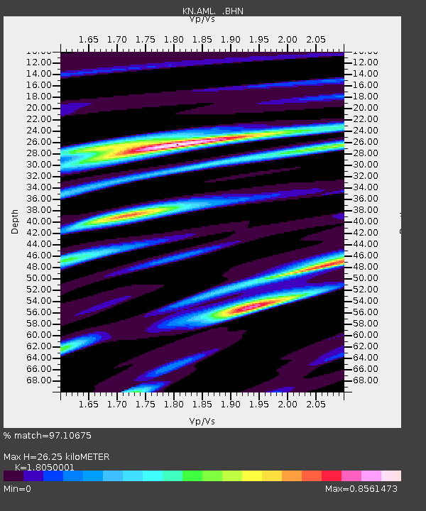
AML KN.AML - Earthquake Result Viewer

Earthquake location: Irian Jaya Region, Indonesia
Earthquake latitude/longitude: -0.4/133.1
Earthquake time(UTC): 2004/07/28 (210) 03:56:28 GMT
Earthquake Depth: 13 km
Earthquake Magnitude: 6.0 MB, 6.3 MS, 6.5 MW, 6.4 MW
Earthquake Catalog/Contributor: WHDF/NEIC
Network: KN Kyrgyz Seismic Telemetry Network
Station: AML KN.AML
Lat/Lon: 42.13 N/73.69 E
Elevation: 3400 m
Distance: 68.1 deg
Az: 316.354 deg
Baz: 111.897 deg
Ray Param: 0.056540214
Estimated Moho Depth: 26.25 km
Estimated Crust Vp/Vs: 1.81
Assumed Crust Vp: 6.316 km/s
Estimated Crust Vs: 3.499 km/s
Estimated Crust Poisson's Ratio: 0.28
Radial Match: 97.10675 %
Radial Bump: 400
Transverse Match: 92.58728 %
Transverse Bump: 400
SOD ConfigId: 2459
Insert Time: 2010-03-08 18:58:42.013 +0000
GWidth: 2.5
Max Bumps: 400
Tol: 0.001

Signal To Noise

ChannelStoNSTALTA
KN:AML: :BHN:20040728T04:06:56.500024Z13.3438113.7583135E-72.8165218E-8
KN:AML: :BHE:20040728T04:06:56.500024Z32.287017.7773785E-72.4088258E-8
KN:AML: :BHZ:20040728T04:06:56.500024Z53.3731351.8870572E-63.535594E-8
Arrivals
Ps3.5 SECOND
PpPs11 SECOND
PsPs/PpSs15 SECOND