You are here: Home > Network List > GS - US Geological Survey Networks Stations List
> Station OK031 S. Brethren Rd., Cushing, OK, USA > Earthquake Result Viewer
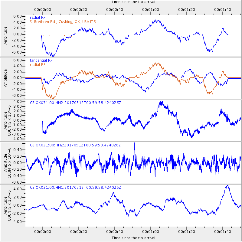
OK031 S. Brethren Rd., Cushing, OK, USA - Earthquake Result Viewer
*The percent match for this event was below the threshold and hence no stack was calculated.
| Earthquake location: |
Kermadec Islands Region |
| Earthquake latitude/longitude: |
-27.5/-176.9 |
| Earthquake time(UTC): |
2017/05/12 (132) 00:46:52 GMT |
| Earthquake Depth: |
10 km |
| Earthquake Magnitude: |
5.8 mb |
| Earthquake Catalog/Contributor: |
NEIC PDE/us |
|
| Network: |
GS US Geological Survey Networks |
| Station: |
OK031 S. Brethren Rd., Cushing, OK, USA |
| Lat/Lon: |
35.95 N/96.84 W |
| Elevation: |
290 m |
|
| Distance: |
98.2 deg |
| Az: |
53.848 deg |
| Baz: |
242.149 deg |
| Ray Param: |
$rayparam |
*The percent match for this event was below the threshold and hence was not used in the summary stack. |
|
| Radial Match: |
48.95027 % |
| Radial Bump: |
400 |
| Transverse Match: |
53.892 % |
| Transverse Bump: |
400 |
| SOD ConfigId: |
2028011 |
| Insert Time: |
2017-05-26 00:57:42.818 +0000 |
| GWidth: |
2.5 |
| Max Bumps: |
400 |
| Tol: |
0.001 |
|
Signal To Noise
| Channel | StoN | STA | LTA |
| GS:OK031:00:HHZ:20170512T00:59:58.424026Z | 1.2814196 | 1.6313413E-7 | 1.2730736E-7 |
| GS:OK031:00:HH1:20170512T00:59:58.424026Z | 1.0825459 | 1.079782E-6 | 9.974469E-7 |
| GS:OK031:00:HH2:20170512T00:59:58.424026Z | 1.421409 | 1.7983925E-6 | 1.2652182E-6 |
| Arrivals |
| Ps | |
| PpPs | |
| PsPs/PpSs | |


