You are here: Home > Network List > IU - Global Seismograph Network (GSN - IRIS/USGS) Stations List
> Station RSSD Black Hills, South Dakota, USA > Earthquake Result Viewer
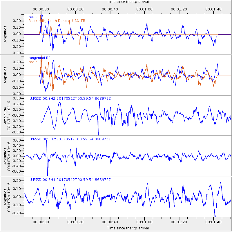
RSSD Black Hills, South Dakota, USA - Earthquake Result Viewer
*The percent match for this event was below the threshold and hence no stack was calculated.
| Earthquake location: |
Kermadec Islands Region |
| Earthquake latitude/longitude: |
-27.5/-176.9 |
| Earthquake time(UTC): |
2017/05/12 (132) 00:46:52 GMT |
| Earthquake Depth: |
10 km |
| Earthquake Magnitude: |
5.8 mb |
| Earthquake Catalog/Contributor: |
NEIC PDE/us |
|
| Network: |
IU Global Seismograph Network (GSN - IRIS/USGS) |
| Station: |
RSSD Black Hills, South Dakota, USA |
| Lat/Lon: |
44.12 N/104.04 W |
| Elevation: |
2090 m |
|
| Distance: |
97.4 deg |
| Az: |
43.943 deg |
| Baz: |
238.877 deg |
| Ray Param: |
$rayparam |
*The percent match for this event was below the threshold and hence was not used in the summary stack. |
|
| Radial Match: |
69.657486 % |
| Radial Bump: |
400 |
| Transverse Match: |
70.52399 % |
| Transverse Bump: |
400 |
| SOD ConfigId: |
2028011 |
| Insert Time: |
2017-05-26 00:58:57.453 +0000 |
| GWidth: |
2.5 |
| Max Bumps: |
400 |
| Tol: |
0.001 |
|
Signal To Noise
| Channel | StoN | STA | LTA |
| IU:RSSD:00:BHZ:20170512T00:59:54.868972Z | 3.2389333 | 2.6463124E-7 | 8.1703206E-8 |
| IU:RSSD:00:BH1:20170512T00:59:54.868972Z | 0.6883405 | 6.077094E-8 | 8.8286164E-8 |
| IU:RSSD:00:BH2:20170512T00:59:54.868972Z | 0.9322008 | 1.05377026E-7 | 1.1304113E-7 |
| Arrivals |
| Ps | |
| PpPs | |
| PsPs/PpSs | |


