You are here: Home > Network List > IW - Intermountain West Stations List
> Station MOOW Moose Ponds, Wyoming, USA > Earthquake Result Viewer
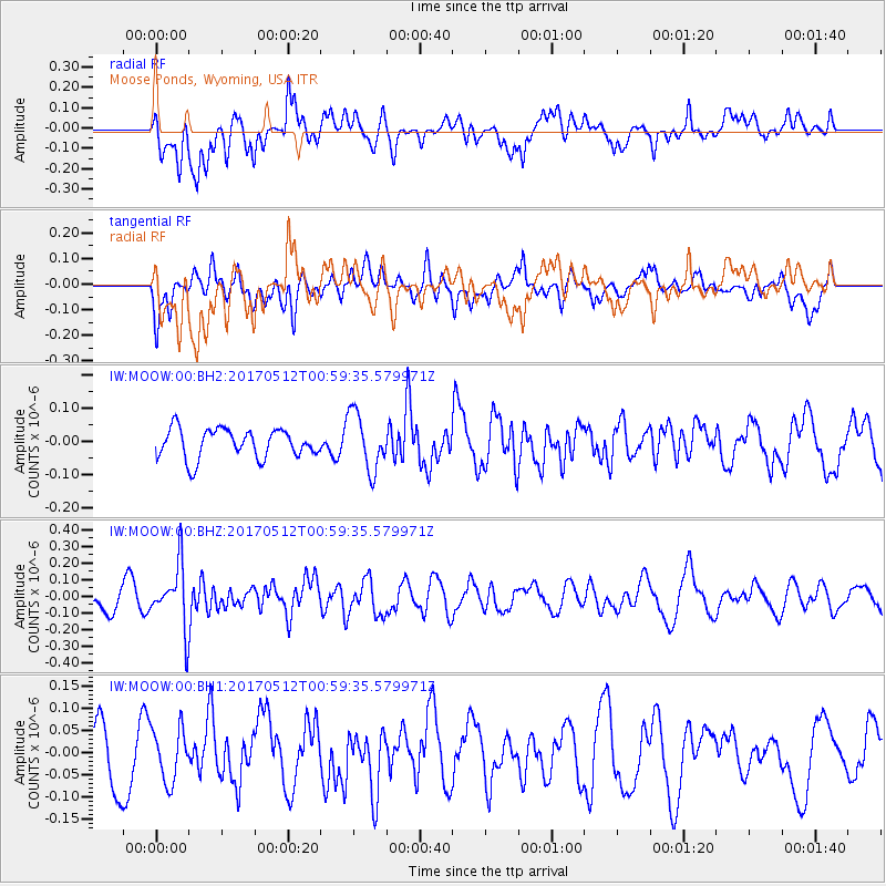
MOOW Moose Ponds, Wyoming, USA - Earthquake Result Viewer
*The percent match for this event was below the threshold and hence no stack was calculated.
| Earthquake location: |
Kermadec Islands Region |
| Earthquake latitude/longitude: |
-27.5/-176.9 |
| Earthquake time(UTC): |
2017/05/12 (132) 00:46:52 GMT |
| Earthquake Depth: |
10 km |
| Earthquake Magnitude: |
5.8 mb |
| Earthquake Catalog/Contributor: |
NEIC PDE/us |
|
| Network: |
IW Intermountain West |
| Station: |
MOOW Moose Ponds, Wyoming, USA |
| Lat/Lon: |
43.75 N/110.74 W |
| Elevation: |
2128 m |
|
| Distance: |
93.2 deg |
| Az: |
41.582 deg |
| Baz: |
234.455 deg |
| Ray Param: |
$rayparam |
*The percent match for this event was below the threshold and hence was not used in the summary stack. |
|
| Radial Match: |
69.990364 % |
| Radial Bump: |
400 |
| Transverse Match: |
45.189766 % |
| Transverse Bump: |
400 |
| SOD ConfigId: |
2028011 |
| Insert Time: |
2017-05-26 00:59:14.845 +0000 |
| GWidth: |
2.5 |
| Max Bumps: |
400 |
| Tol: |
0.001 |
|
Signal To Noise
| Channel | StoN | STA | LTA |
| IW:MOOW:00:BHZ:20170512T00:59:35.579971Z | 3.1068997 | 1.8817057E-7 | 6.0565384E-8 |
| IW:MOOW:00:BH1:20170512T00:59:35.579971Z | 1.2098278 | 5.924937E-8 | 4.897339E-8 |
| IW:MOOW:00:BH2:20170512T00:59:35.579971Z | 1.9640601 | 8.6808946E-8 | 4.419872E-8 |
| Arrivals |
| Ps | |
| PpPs | |
| PsPs/PpSs | |


