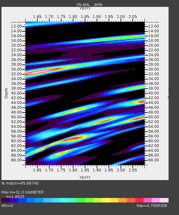
AML KN.AML - Earthquake Result Viewer

Earthquake location: Bonin Islands, Japan Region
Earthquake latitude/longitude: 27.0/142.6
Earthquake time(UTC): 2008/03/14 (074) 22:32:09 GMT
Earthquake Depth: 11 km
Earthquake Magnitude: 5.7 MB, 5.9 MS, 6.0 MW, 6.0 MW
Earthquake Catalog/Contributor: WHDF/NEIC
Network: KN Kyrgyz Seismic Telemetry Network
Station: AML KN.AML
Lat/Lon: 42.13 N/73.69 E
Elevation: 3400 m
Distance: 57.3 deg
Az: 304.42 deg
Baz: 81.724 deg
Ray Param: 0.06359122
Estimated Moho Depth: 31.0 km
Estimated Crust Vp/Vs: 1.65
Assumed Crust Vp: 6.316 km/s
Estimated Crust Vs: 3.822 km/s
Estimated Crust Poisson's Ratio: 0.21
Radial Match: 95.68748 %
Radial Bump: 333
Transverse Match: 83.84527 %
Transverse Bump: 400
SOD ConfigId: 2564
Insert Time: 2010-03-08 19:01:11.917 +0000
GWidth: 2.5
Max Bumps: 400
Tol: 0.001

Signal To Noise

ChannelStoNSTALTA
KN:AML: :BHN:20080314T22:41:26.000012Z3.3775711.16482504E-73.4487062E-8
KN:AML: :BHE:20080314T22:41:26.000012Z11.27654654.871028E-74.3196096E-8
KN:AML: :BHZ:20080314T22:41:26.000012Z13.0176669.797265E-77.5261305E-8
Arrivals
Ps3.4 SECOND
PpPs12 SECOND
PsPs/PpSs16 SECOND