You are here: Home > Network List > US - United States National Seismic Network Stations List
> Station EGMT Eagleton, Montana, USA > Earthquake Result Viewer
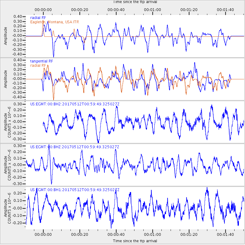
EGMT Eagleton, Montana, USA - Earthquake Result Viewer
*The percent match for this event was below the threshold and hence no stack was calculated.
| Earthquake location: |
Kermadec Islands Region |
| Earthquake latitude/longitude: |
-27.5/-176.9 |
| Earthquake time(UTC): |
2017/05/12 (132) 00:46:52 GMT |
| Earthquake Depth: |
10 km |
| Earthquake Magnitude: |
5.8 mb |
| Earthquake Catalog/Contributor: |
NEIC PDE/us |
|
| Network: |
US United States National Seismic Network |
| Station: |
EGMT Eagleton, Montana, USA |
| Lat/Lon: |
48.02 N/109.75 W |
| Elevation: |
1055 m |
|
| Distance: |
96.2 deg |
| Az: |
38.469 deg |
| Baz: |
235.419 deg |
| Ray Param: |
$rayparam |
*The percent match for this event was below the threshold and hence was not used in the summary stack. |
|
| Radial Match: |
50.544086 % |
| Radial Bump: |
400 |
| Transverse Match: |
51.615345 % |
| Transverse Bump: |
400 |
| SOD ConfigId: |
2028011 |
| Insert Time: |
2017-05-26 01:00:05.577 +0000 |
| GWidth: |
2.5 |
| Max Bumps: |
400 |
| Tol: |
0.001 |
|
Signal To Noise
| Channel | StoN | STA | LTA |
| US:EGMT:00:BHZ:20170512T00:59:49.325027Z | 2.0976126 | 1.5451953E-7 | 7.3664474E-8 |
| US:EGMT:00:BH1:20170512T00:59:49.325027Z | 1.3330897 | 1.06493495E-7 | 7.988472E-8 |
| US:EGMT:00:BH2:20170512T00:59:49.325027Z | 1.7706538 | 1.9730783E-7 | 1.11432186E-7 |
| Arrivals |
| Ps | |
| PpPs | |
| PsPs/PpSs | |


