You are here: Home > Network List > US - United States National Seismic Network Stations List
> Station WMOK Wichita Mountains, Oklahoma, USA > Earthquake Result Viewer
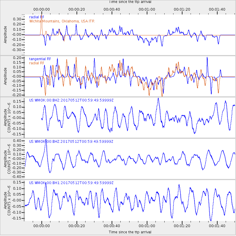
WMOK Wichita Mountains, Oklahoma, USA - Earthquake Result Viewer
*The percent match for this event was below the threshold and hence no stack was calculated.
| Earthquake location: |
Kermadec Islands Region |
| Earthquake latitude/longitude: |
-27.5/-176.9 |
| Earthquake time(UTC): |
2017/05/12 (132) 00:46:52 GMT |
| Earthquake Depth: |
10 km |
| Earthquake Magnitude: |
5.8 mb |
| Earthquake Catalog/Contributor: |
NEIC PDE/us |
|
| Network: |
US United States National Seismic Network |
| Station: |
WMOK Wichita Mountains, Oklahoma, USA |
| Lat/Lon: |
34.74 N/98.78 W |
| Elevation: |
486 m |
|
| Distance: |
96.3 deg |
| Az: |
54.161 deg |
| Baz: |
240.991 deg |
| Ray Param: |
$rayparam |
*The percent match for this event was below the threshold and hence was not used in the summary stack. |
|
| Radial Match: |
59.095016 % |
| Radial Bump: |
400 |
| Transverse Match: |
74.78416 % |
| Transverse Bump: |
400 |
| SOD ConfigId: |
2028011 |
| Insert Time: |
2017-05-26 01:01:05.787 +0000 |
| GWidth: |
2.5 |
| Max Bumps: |
400 |
| Tol: |
0.001 |
|
Signal To Noise
| Channel | StoN | STA | LTA |
| US:WMOK:00:BHZ:20170512T00:59:49.59999Z | 1.7387581 | 2.1759902E-7 | 1.2514623E-7 |
| US:WMOK:00:BH1:20170512T00:59:49.59999Z | 1.9305485 | 8.557635E-8 | 4.4327482E-8 |
| US:WMOK:00:BH2:20170512T00:59:49.59999Z | 0.8141919 | 5.289562E-8 | 6.496702E-8 |
| Arrivals |
| Ps | |
| PpPs | |
| PsPs/PpSs | |


