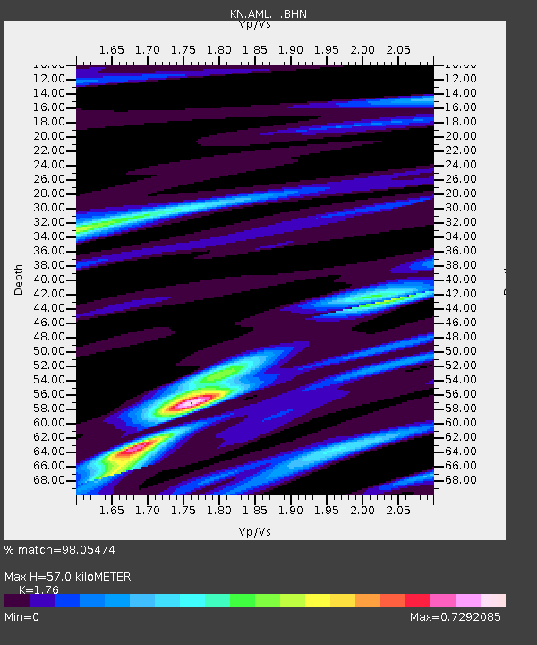
AML KN.AML - Earthquake Result Viewer

Earthquake location: Andreanof Islands, Aleutian Is.
Earthquake latitude/longitude: 51.5/-176.8
Earthquake time(UTC): 1996/06/10 (162) 15:24:56 GMT
Earthquake Depth: 26 km
Earthquake Magnitude: 5.9 MB, 7.1 MS, 7.2 UNKNOWN, 6.9 MS
Earthquake Catalog/Contributor: WHDF/NEIC
Network: KN Kyrgyz Seismic Telemetry Network
Station: AML KN.AML
Lat/Lon: 42.13 N/73.69 E
Elevation: 3400 m
Distance: 68.5 deg
Az: 311.077 deg
Baz: 39.329 deg
Ray Param: 0.05623134
Estimated Moho Depth: 57.0 km
Estimated Crust Vp/Vs: 1.76
Assumed Crust Vp: 6.316 km/s
Estimated Crust Vs: 3.588 km/s
Estimated Crust Poisson's Ratio: 0.26
Radial Match: 98.05474 %
Radial Bump: 354
Transverse Match: 92.48061 %
Transverse Bump: 400
SOD ConfigId: 6273
Insert Time: 2010-03-08 19:02:35.315 +0000
GWidth: 2.5
Max Bumps: 400
Tol: 0.001

Signal To Noise

ChannelStoNSTALTA
KN:AML: :BHN:19960610T15:35:24.875Z1.74489979.48094E-85.4335157E-8
KN:AML: :BHE:19960610T15:35:24.875Z1.88071129.765624E-85.1925166E-8
KN:AML: :BHZ:19960610T15:35:24.875Z2.95653413.3140265E-71.1209161E-7
Arrivals
Ps7.1 SECOND
PpPs24 SECOND
PsPs/PpSs31 SECOND