You are here: Home > Network List > TA - USArray Transportable Network (new EarthScope stations) Stations List
> Station C16K Lisburne Hills, AK, USA > Earthquake Result Viewer
C16K Lisburne Hills, AK, USA - Earthquake Result Viewer
| Earthquake location: |
Northern Molucca Sea |
| Earthquake latitude/longitude: |
1.4/126.4 |
| Earthquake time(UTC): |
2020/04/05 (096) 18:37:10 GMT |
| Earthquake Depth: |
54 km |
| Earthquake Magnitude: |
5.9 Mww |
| Earthquake Catalog/Contributor: |
NEIC PDE/us |
|
| Network: |
TA USArray Transportable Network (new EarthScope stations) |
| Station: |
C16K Lisburne Hills, AK, USA |
| Lat/Lon: |
68.27 N/165.34 W |
| Elevation: |
102 m |
|
| Distance: |
80.8 deg |
| Az: |
20.504 deg |
| Baz: |
250.139 deg |
| Ray Param: |
0.04796679 |
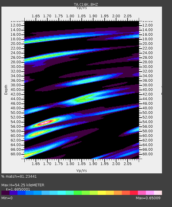
| Estimated Moho Depth: |
54.25 km |
| Estimated Crust Vp/Vs: |
1.69 |
| Assumed Crust Vp: |
5.906 km/s |
| Estimated Crust Vs: |
3.505 km/s |
| Estimated Crust Poisson's Ratio: |
0.23 |
|
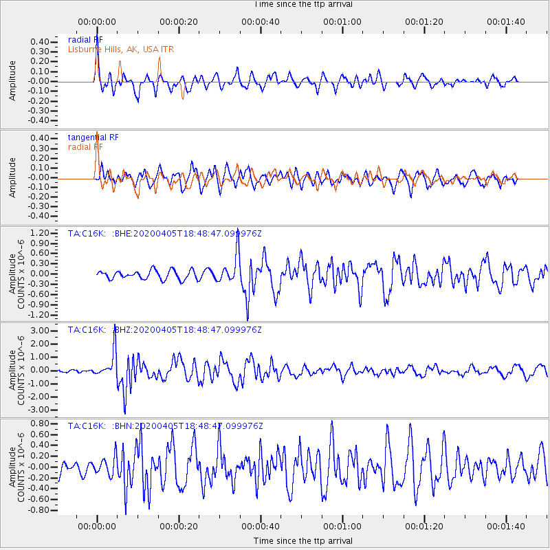
| Radial Match: |
81.23441 % |
| Radial Bump: |
400 |
| Transverse Match: |
74.05303 % |
| Transverse Bump: |
400 |
| SOD ConfigId: |
21144311 |
| Insert Time: |
2020-04-19 18:45:22.191 +0000 |
| GWidth: |
2.5 |
| Max Bumps: |
400 |
| Tol: |
0.001 |
|
Signal To Noise
| Channel | StoN | STA | LTA |
| TA:C16K: :BHZ:20200405T18:48:47.099976Z | 5.7303796 | 1.0292152E-6 | 1.7960681E-7 |
| TA:C16K: :BHN:20200405T18:48:47.099976Z | 1.1618502 | 1.7251155E-7 | 1.4848001E-7 |
| TA:C16K: :BHE:20200405T18:48:47.099976Z | 3.5309608 | 4.4920552E-7 | 1.2721905E-7 |
| Arrivals |
| Ps | 6.4 SECOND |
| PpPs | 24 SECOND |
| PsPs/PpSs | 31 SECOND |


