You are here: Home > Network List > TA - USArray Transportable Network (new EarthScope stations) Stations List
> Station E18K Tukpahlearik Creek, AK, USA > Earthquake Result Viewer
E18K Tukpahlearik Creek, AK, USA - Earthquake Result Viewer
| Earthquake location: |
Northern Molucca Sea |
| Earthquake latitude/longitude: |
1.4/126.4 |
| Earthquake time(UTC): |
2020/04/05 (096) 18:37:10 GMT |
| Earthquake Depth: |
54 km |
| Earthquake Magnitude: |
5.9 Mww |
| Earthquake Catalog/Contributor: |
NEIC PDE/us |
|
| Network: |
TA USArray Transportable Network (new EarthScope stations) |
| Station: |
E18K Tukpahlearik Creek, AK, USA |
| Lat/Lon: |
67.42 N/160.60 W |
| Elevation: |
297 m |
|
| Distance: |
82.2 deg |
| Az: |
21.878 deg |
| Baz: |
254.73 deg |
| Ray Param: |
0.046952862 |
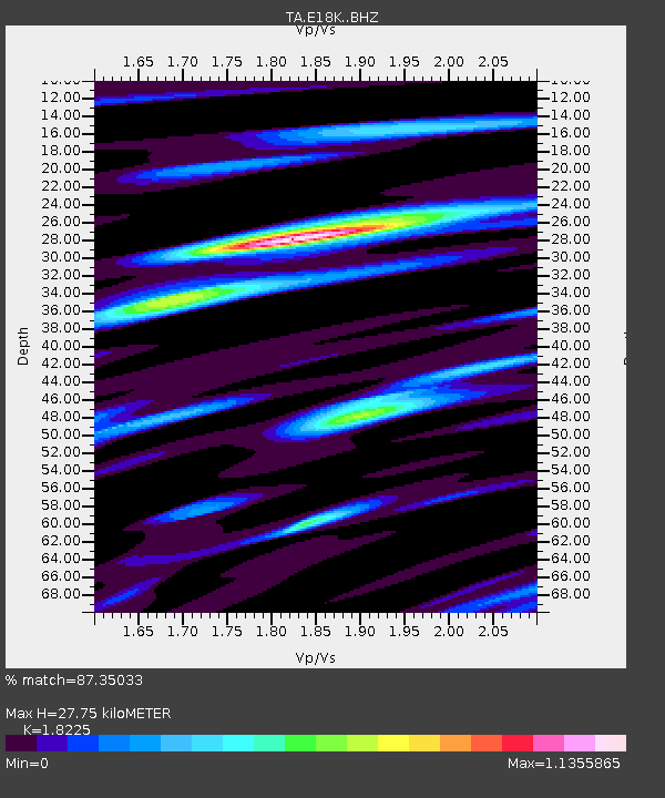
| Estimated Moho Depth: |
27.75 km |
| Estimated Crust Vp/Vs: |
1.82 |
| Assumed Crust Vp: |
6.276 km/s |
| Estimated Crust Vs: |
3.444 km/s |
| Estimated Crust Poisson's Ratio: |
0.28 |
|
| Radial Match: |
87.35033 % |
| Radial Bump: |
400 |
| Transverse Match: |
84.36882 % |
| Transverse Bump: |
400 |
| SOD ConfigId: |
21144311 |
| Insert Time: |
2020-04-19 18:45:44.766 +0000 |
| GWidth: |
2.5 |
| Max Bumps: |
400 |
| Tol: |
0.001 |
|
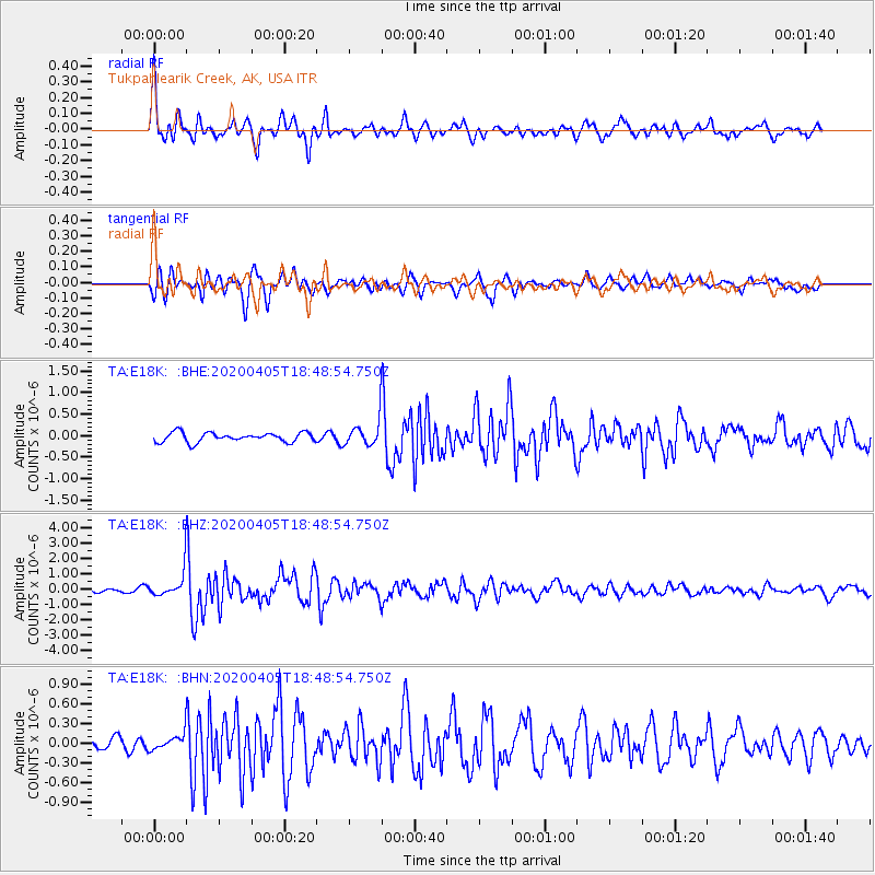
Signal To Noise
| Channel | StoN | STA | LTA |
| TA:E18K: :BHZ:20200405T18:48:54.750Z | 7.1021514 | 7.8688237E-7 | 1.1079493E-7 |
| TA:E18K: :BHN:20200405T18:48:54.750Z | 1.1483493 | 1.16170725E-7 | 1.01163224E-7 |
| TA:E18K: :BHE:20200405T18:48:54.750Z | 2.6431916 | 2.8722235E-7 | 1.0866498E-7 |
| Arrivals |
| Ps | 3.7 SECOND |
| PpPs | 12 SECOND |
| PsPs/PpSs | 16 SECOND |


