You are here: Home > Network List > TA - USArray Transportable Network (new EarthScope stations) Stations List
> Station F20K Avaraart Lake, AK, USA > Earthquake Result Viewer
F20K Avaraart Lake, AK, USA - Earthquake Result Viewer
| Earthquake location: |
Northern Molucca Sea |
| Earthquake latitude/longitude: |
1.4/126.4 |
| Earthquake time(UTC): |
2020/04/05 (096) 18:37:10 GMT |
| Earthquake Depth: |
54 km |
| Earthquake Magnitude: |
5.9 Mww |
| Earthquake Catalog/Contributor: |
NEIC PDE/us |
|
| Network: |
TA USArray Transportable Network (new EarthScope stations) |
| Station: |
F20K Avaraart Lake, AK, USA |
| Lat/Lon: |
67.05 N/155.73 W |
| Elevation: |
136 m |
|
| Distance: |
84.0 deg |
| Az: |
22.674 deg |
| Baz: |
259.319 deg |
| Ray Param: |
0.045715075 |
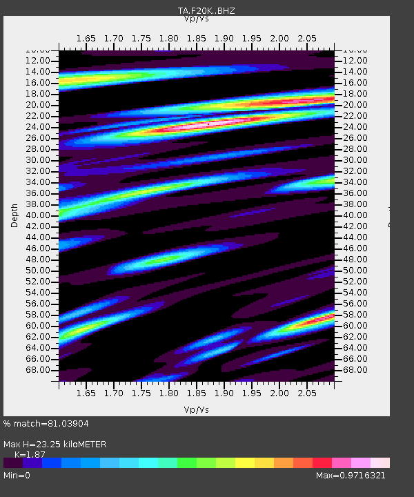
| Estimated Moho Depth: |
23.25 km |
| Estimated Crust Vp/Vs: |
1.87 |
| Assumed Crust Vp: |
6.522 km/s |
| Estimated Crust Vs: |
3.487 km/s |
| Estimated Crust Poisson's Ratio: |
0.30 |
|
| Radial Match: |
81.03904 % |
| Radial Bump: |
400 |
| Transverse Match: |
81.61431 % |
| Transverse Bump: |
400 |
| SOD ConfigId: |
21144311 |
| Insert Time: |
2020-04-19 18:46:03.691 +0000 |
| GWidth: |
2.5 |
| Max Bumps: |
400 |
| Tol: |
0.001 |
|
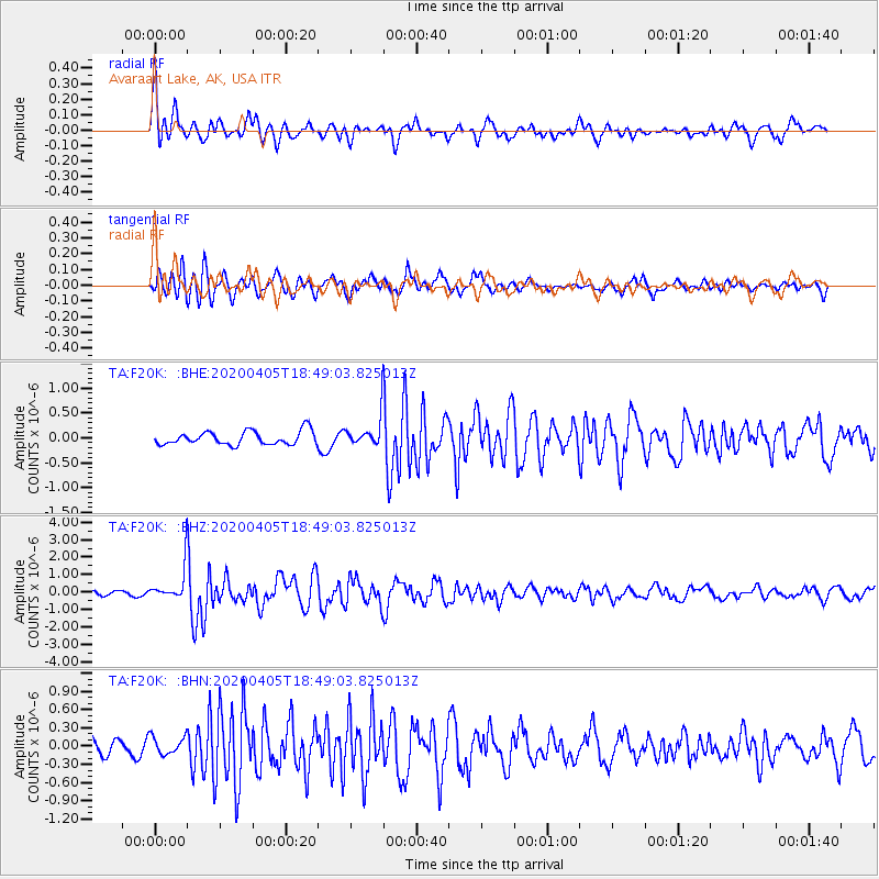
Signal To Noise
| Channel | StoN | STA | LTA |
| TA:F20K: :BHZ:20200405T18:49:03.825013Z | 10.452452 | 9.083982E-7 | 8.690767E-8 |
| TA:F20K: :BHN:20200405T18:49:03.825013Z | 1.0352525 | 1.5032948E-7 | 1.4521046E-7 |
| TA:F20K: :BHE:20200405T18:49:03.825013Z | 2.1836917 | 2.9376352E-7 | 1.3452609E-7 |
| Arrivals |
| Ps | 3.2 SECOND |
| PpPs | 10.0 SECOND |
| PsPs/PpSs | 13 SECOND |


