You are here: Home > Network List > TA - USArray Transportable Network (new EarthScope stations) Stations List
> Station F21K Alatna River, AK, USA > Earthquake Result Viewer
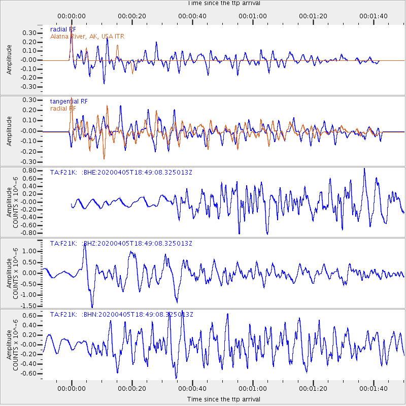
F21K Alatna River, AK, USA - Earthquake Result Viewer
*The percent match for this event was below the threshold and hence no stack was calculated.
| Earthquake location: |
Northern Molucca Sea |
| Earthquake latitude/longitude: |
1.4/126.4 |
| Earthquake time(UTC): |
2020/04/05 (096) 18:37:10 GMT |
| Earthquake Depth: |
54 km |
| Earthquake Magnitude: |
5.9 Mww |
| Earthquake Catalog/Contributor: |
NEIC PDE/us |
|
| Network: |
TA USArray Transportable Network (new EarthScope stations) |
| Station: |
F21K Alatna River, AK, USA |
| Lat/Lon: |
67.22 N/153.48 W |
| Elevation: |
597 m |
|
| Distance: |
84.9 deg |
| Az: |
22.649 deg |
| Baz: |
261.381 deg |
| Ray Param: |
$rayparam |
*The percent match for this event was below the threshold and hence was not used in the summary stack. |
|
| Radial Match: |
77.6125 % |
| Radial Bump: |
400 |
| Transverse Match: |
71.30479 % |
| Transverse Bump: |
400 |
| SOD ConfigId: |
21144311 |
| Insert Time: |
2020-04-19 18:46:06.084 +0000 |
| GWidth: |
2.5 |
| Max Bumps: |
400 |
| Tol: |
0.001 |
|
Signal To Noise
| Channel | StoN | STA | LTA |
| TA:F21K: :BHZ:20200405T18:49:08.325013Z | 3.5351946 | 5.235878E-7 | 1.481072E-7 |
| TA:F21K: :BHN:20200405T18:49:08.325013Z | 0.5161013 | 7.389906E-8 | 1.4318712E-7 |
| TA:F21K: :BHE:20200405T18:49:08.325013Z | 1.5123341 | 1.2265693E-7 | 8.110439E-8 |
| Arrivals |
| Ps | |
| PpPs | |
| PsPs/PpSs | |


