You are here: Home > Network List > TS - TERRAscope (Southern California Seismic Network) Stations List
> Station SBC Santa Barbara, California, USA > Earthquake Result Viewer
SBC Santa Barbara, California, USA - Earthquake Result Viewer
| Earthquake location: |
Bering Sea |
| Earthquake latitude/longitude: |
58.4/-175.4 |
| Earthquake time(UTC): |
1991/02/21 (052) 02:35:32 GMT |
| Earthquake Depth: |
10 km |
| Earthquake Magnitude: |
6.3 MB, 6.5 MS, 6.7 UNKNOWN |
| Earthquake Catalog/Contributor: |
WHDF/NEIC |
|
| Network: |
TS TERRAscope (Southern California Seismic Network) |
| Station: |
SBC Santa Barbara, California, USA |
| Lat/Lon: |
34.44 N/119.71 W |
| Elevation: |
90 m |
|
| Distance: |
43.6 deg |
| Az: |
98.283 deg |
| Baz: |
320.942 deg |
| Ray Param: |
0.0724177 |
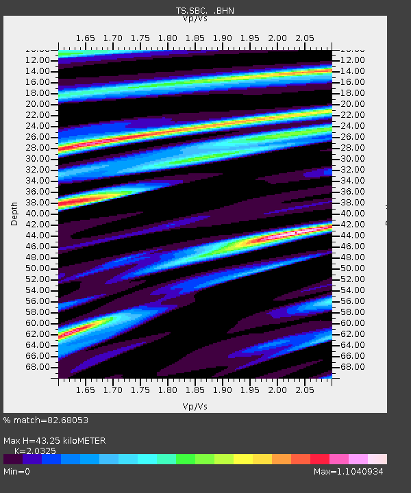
| Estimated Moho Depth: |
43.25 km |
| Estimated Crust Vp/Vs: |
2.03 |
| Assumed Crust Vp: |
6.1 km/s |
| Estimated Crust Vs: |
3.001 km/s |
| Estimated Crust Poisson's Ratio: |
0.34 |
|
| Radial Match: |
82.68053 % |
| Radial Bump: |
400 |
| Transverse Match: |
81.93998 % |
| Transverse Bump: |
400 |
| SOD ConfigId: |
16938 |
| Insert Time: |
2010-02-26 14:46:17.105 +0000 |
| GWidth: |
2.5 |
| Max Bumps: |
400 |
| Tol: |
0.001 |
|

Signal To Noise
| Channel | StoN | STA | LTA |
| TS:SBC: :BHN:19910221T02:43:06.152991Z | 1.6178836 | 7.975747E-7 | 4.9297415E-7 |
| TS:SBC: :BHE:19910221T02:43:06.152991Z | 0.9732935 | 5.007226E-7 | 5.1446204E-7 |
| TS:SBC: :BHZ:19910221T02:43:06.152991Z | 2.6499424 | 7.283188E-7 | 2.7484325E-7 |
| Arrivals |
| Ps | 7.7 SECOND |
| PpPs | 20 SECOND |
| PsPs/PpSs | 28 SECOND |


