You are here: Home > Network List > IU - Global Seismograph Network (GSN - IRIS/USGS) Stations List
> Station POHA Pohakuloa, Hawaii, USA > Earthquake Result Viewer
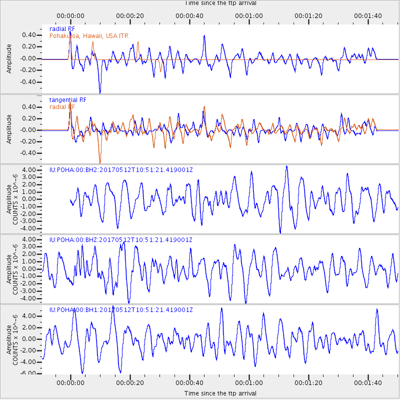
POHA Pohakuloa, Hawaii, USA - Earthquake Result Viewer
*The percent match for this event was below the threshold and hence no stack was calculated.
| Earthquake location: |
Off Coast Of Central America |
| Earthquake latitude/longitude: |
12.9/-90.1 |
| Earthquake time(UTC): |
2017/05/12 (132) 10:41:26 GMT |
| Earthquake Depth: |
10 km |
| Earthquake Magnitude: |
6.2 Mww |
| Earthquake Catalog/Contributor: |
NEIC PDE/us |
|
| Network: |
IU Global Seismograph Network (GSN - IRIS/USGS) |
| Station: |
POHA Pohakuloa, Hawaii, USA |
| Lat/Lon: |
19.76 N/155.53 W |
| Elevation: |
1990 m |
|
| Distance: |
62.9 deg |
| Az: |
285.7 deg |
| Baz: |
85.289 deg |
| Ray Param: |
$rayparam |
*The percent match for this event was below the threshold and hence was not used in the summary stack. |
|
| Radial Match: |
61.087822 % |
| Radial Bump: |
400 |
| Transverse Match: |
48.79481 % |
| Transverse Bump: |
400 |
| SOD ConfigId: |
2028011 |
| Insert Time: |
2017-05-26 10:48:14.450 +0000 |
| GWidth: |
2.5 |
| Max Bumps: |
400 |
| Tol: |
0.001 |
|
Signal To Noise
| Channel | StoN | STA | LTA |
| IU:POHA:00:BHZ:20170512T10:51:21.419001Z | 1.1882538 | 1.5792637E-6 | 1.3290626E-6 |
| IU:POHA:00:BH1:20170512T10:51:21.419001Z | 1.949483 | 3.3535139E-6 | 1.7202068E-6 |
| IU:POHA:00:BH2:20170512T10:51:21.419001Z | 0.7980699 | 1.2728846E-6 | 1.5949537E-6 |
| Arrivals |
| Ps | |
| PpPs | |
| PsPs/PpSs | |


