You are here: Home > Network List > IU - Global Seismograph Network (GSN - IRIS/USGS) Stations List
> Station RSSD Black Hills, South Dakota, USA > Earthquake Result Viewer
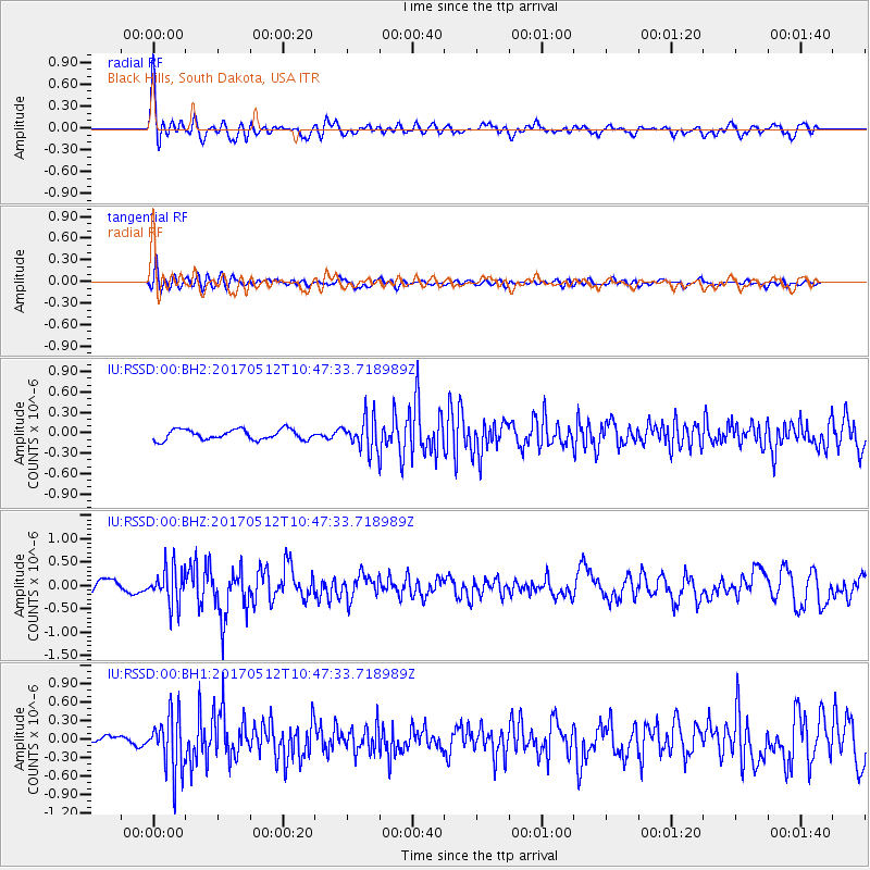
RSSD Black Hills, South Dakota, USA - Earthquake Result Viewer
*The percent match for this event was below the threshold and hence no stack was calculated.
| Earthquake location: |
Off Coast Of Central America |
| Earthquake latitude/longitude: |
12.9/-90.1 |
| Earthquake time(UTC): |
2017/05/12 (132) 10:41:26 GMT |
| Earthquake Depth: |
10 km |
| Earthquake Magnitude: |
6.2 Mww |
| Earthquake Catalog/Contributor: |
NEIC PDE/us |
|
| Network: |
IU Global Seismograph Network (GSN - IRIS/USGS) |
| Station: |
RSSD Black Hills, South Dakota, USA |
| Lat/Lon: |
44.12 N/104.04 W |
| Elevation: |
2090 m |
|
| Distance: |
33.3 deg |
| Az: |
341.543 deg |
| Baz: |
154.62 deg |
| Ray Param: |
$rayparam |
*The percent match for this event was below the threshold and hence was not used in the summary stack. |
|
| Radial Match: |
77.6602 % |
| Radial Bump: |
400 |
| Transverse Match: |
65.86764 % |
| Transverse Bump: |
400 |
| SOD ConfigId: |
2028011 |
| Insert Time: |
2017-05-26 10:48:18.324 +0000 |
| GWidth: |
2.5 |
| Max Bumps: |
400 |
| Tol: |
0.001 |
|
Signal To Noise
| Channel | StoN | STA | LTA |
| IU:RSSD:00:BHZ:20170512T10:47:33.718989Z | 2.6615376 | 3.811873E-7 | 1.432207E-7 |
| IU:RSSD:00:BH1:20170512T10:47:33.718989Z | 11.542635 | 4.6475594E-7 | 4.0264286E-8 |
| IU:RSSD:00:BH2:20170512T10:47:33.718989Z | 3.1317887 | 2.351545E-7 | 7.508632E-8 |
| Arrivals |
| Ps | |
| PpPs | |
| PsPs/PpSs | |


