You are here: Home > Network List > TA - USArray Transportable Network (new EarthScope stations) Stations List
> Station F17K Baldwin Penninsula, AK, USA > Earthquake Result Viewer
F17K Baldwin Penninsula, AK, USA - Earthquake Result Viewer
| Earthquake location: |
Western Idaho |
| Earthquake latitude/longitude: |
44.5/-115.1 |
| Earthquake time(UTC): |
2020/03/31 (091) 23:52:30 GMT |
| Earthquake Depth: |
10 km |
| Earthquake Magnitude: |
6.8 Ml |
| Earthquake Catalog/Contributor: |
NEIC PDE/us |
|
| Network: |
TA USArray Transportable Network (new EarthScope stations) |
| Station: |
F17K Baldwin Penninsula, AK, USA |
| Lat/Lon: |
66.44 N/161.25 W |
| Elevation: |
51 m |
|
| Distance: |
33.0 deg |
| Az: |
327.838 deg |
| Baz: |
108.58 deg |
| Ray Param: |
0.07841899 |
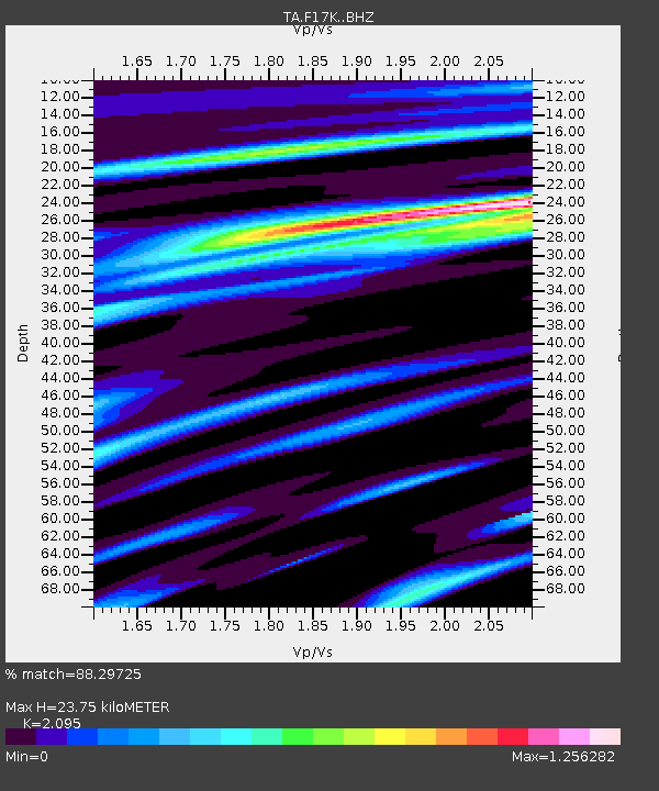
| Estimated Moho Depth: |
23.75 km |
| Estimated Crust Vp/Vs: |
2.10 |
| Assumed Crust Vp: |
6.276 km/s |
| Estimated Crust Vs: |
2.996 km/s |
| Estimated Crust Poisson's Ratio: |
0.35 |
|
| Radial Match: |
88.29725 % |
| Radial Bump: |
384 |
| Transverse Match: |
81.547485 % |
| Transverse Bump: |
374 |
| SOD ConfigId: |
21166931 |
| Insert Time: |
2020-04-24 12:20:20.527 +0000 |
| GWidth: |
2.5 |
| Max Bumps: |
400 |
| Tol: |
0.001 |
|

Signal To Noise
| Channel | StoN | STA | LTA |
| TA:F17K: :BHZ:20200331T23:58:34.774985Z | 1.8147186 | 2.2584379E-7 | 1.2445113E-7 |
| TA:F17K: :BHN:20200331T23:58:34.774985Z | 1.0123432 | 1.0785825E-7 | 1.0654316E-7 |
| TA:F17K: :BHE:20200331T23:58:34.774985Z | 0.5699845 | 6.798628E-8 | 1.1927742E-7 |
| Arrivals |
| Ps | 4.4 SECOND |
| PpPs | 11 SECOND |
| PsPs/PpSs | 15 SECOND |


