You are here: Home > Network List > AK - Alaska Regional Network Stations List
> Station CUT Chulitna, AK, USA > Earthquake Result Viewer
CUT Chulitna, AK, USA - Earthquake Result Viewer
*The percent match for this event was below the threshold and hence no stack was calculated.
| Earthquake location: |
Philippine Islands Region |
| Earthquake latitude/longitude: |
20.4/122.1 |
| Earthquake time(UTC): |
2020/04/10 (101) 16:44:55 GMT |
| Earthquake Depth: |
149 km |
| Earthquake Magnitude: |
5.9 mww |
| Earthquake Catalog/Contributor: |
NEIC PDE/us |
|
| Network: |
AK Alaska Regional Network |
| Station: |
CUT Chulitna, AK, USA |
| Lat/Lon: |
62.41 N/150.26 W |
| Elevation: |
574 m |
|
| Distance: |
71.0 deg |
| Az: |
29.472 deg |
| Baz: |
277.722 deg |
| Ray Param: |
$rayparam |
*The percent match for this event was below the threshold and hence was not used in the summary stack. |
|
| Radial Match: |
74.36317 % |
| Radial Bump: |
400 |
| Transverse Match: |
72.87486 % |
| Transverse Bump: |
400 |
| SOD ConfigId: |
21166931 |
| Insert Time: |
2020-04-24 16:45:54.003 +0000 |
| GWidth: |
2.5 |
| Max Bumps: |
400 |
| Tol: |
0.001 |
|
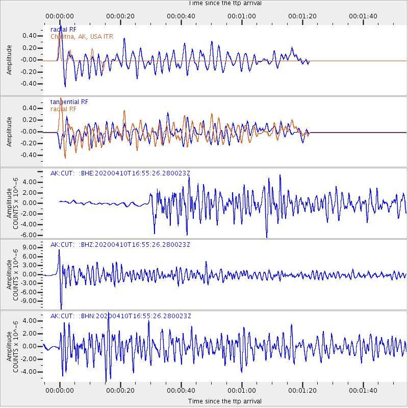
Signal To Noise
| Channel | StoN | STA | LTA |
| AK:CUT: :BHZ:20200410T16:55:26.280023Z | 40.45855 | 4.172385E-6 | 1.03127405E-7 |
| AK:CUT: :BHN:20200410T16:55:26.280023Z | 6.978139 | 2.0846567E-6 | 2.9874107E-7 |
| AK:CUT: :BHE:20200410T16:55:26.280023Z | 8.486116 | 1.9345607E-6 | 2.2796773E-7 |
| Arrivals |
| Ps | |
| PpPs | |
| PsPs/PpSs | |


