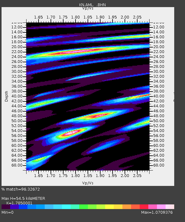
AML KN.AML - Earthquake Result Viewer

Earthquake location: Southwest Of Sumatra, Indonesia
Earthquake latitude/longitude: -0.2/97.7
Earthquake time(UTC): 2005/04/08 (098) 05:48:37 GMT
Earthquake Depth: 21 km
Earthquake Magnitude: 5.7 MB, 6.3 MS, 6.1 MW, 6.1 MW
Earthquake Catalog/Contributor: WHDF/NEIC
Network: KN Kyrgyz Seismic Telemetry Network
Station: AML KN.AML
Lat/Lon: 42.13 N/73.69 E
Elevation: 3400 m
Distance: 47.4 deg
Az: 335.695 deg
Baz: 146.404 deg
Ray Param: 0.06998417
Estimated Moho Depth: 54.5 km
Estimated Crust Vp/Vs: 1.79
Assumed Crust Vp: 6.316 km/s
Estimated Crust Vs: 3.538 km/s
Estimated Crust Poisson's Ratio: 0.27
Radial Match: 96.32672 %
Radial Bump: 353
Transverse Match: 85.123795 %
Transverse Bump: 400
SOD ConfigId: 2459
Insert Time: 2010-03-08 19:05:39.269 +0000
GWidth: 2.5
Max Bumps: 400
Tol: 0.001

Signal To Noise

ChannelStoNSTALTA
KN:AML: :BHN:20050408T05:56:39.774012Z2.06758282.2028668E-71.0654309E-7
KN:AML: :BHE:20050408T05:56:39.774012Z2.49543622.2056594E-78.838773E-8
KN:AML: :BHZ:20050408T05:56:39.774012Z5.29628473.6664858E-76.922751E-8
Arrivals
Ps7.2 SECOND
PpPs23 SECOND
PsPs/PpSs30 SECOND