You are here: Home > Network List > TS - TERRAscope (Southern California Seismic Network) Stations List
> Station SBC Santa Barbara, California, USA > Earthquake Result Viewer
SBC Santa Barbara, California, USA - Earthquake Result Viewer

| Earthquake location: |
Alaska Peninsula |
| Earthquake latitude/longitude: |
54.5/-161.6 |
| Earthquake time(UTC): |
1991/05/30 (150) 13:17:44 GMT |
| Earthquake Depth: |
47 km |
| Earthquake Magnitude: |
6.2 MB, 6.7 MS, 6.8 UNKNOWN |
| Earthquake Catalog/Contributor: |
WHDF/NEIC |
|
| Network: |
TS TERRAscope (Southern California Seismic Network) |
| Station: |
SBC Santa Barbara, California, USA |
| Lat/Lon: |
34.44 N/119.71 W |
| Elevation: |
90 m |
|
| Distance: |
35.3 deg |
| Az: |
107.305 deg |
| Baz: |
317.671 deg |
| Ray Param: |
0.077186204 |
| Estimated Moho Depth: |
64.0 km |
| Estimated Crust Vp/Vs: |
2.02 |
| Assumed Crust Vp: |
6.1 km/s |
| Estimated Crust Vs: |
3.02 km/s |
| Estimated Crust Poisson's Ratio: |
0.34 |
|
| Radial Match: |
89.112915 % |
| Radial Bump: |
400 |
| Transverse Match: |
88.16035 % |
| Transverse Bump: |
400 |
| SOD ConfigId: |
16938 |
| Insert Time: |
2010-02-26 14:46:21.556 +0000 |
| GWidth: |
2.5 |
| Max Bumps: |
400 |
| Tol: |
0.001 |
|
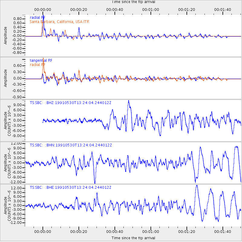
Signal To Noise
| Channel | StoN | STA | LTA |
| TS:SBC: :BHN:19910530T13:24:04.244012Z | 0.99268496 | 7.898504E-7 | 7.9567076E-7 |
| TS:SBC: :BHE:19910530T13:24:04.244012Z | 1.3166492 | 8.598172E-7 | 6.530344E-7 |
| TS:SBC: :BHZ:19910530T13:24:04.244012Z | 2.962504 | 1.8464032E-6 | 6.232576E-7 |
| Arrivals |
| Ps | 11 SECOND |
| PpPs | 30 SECOND |
| PsPs/PpSs | 41 SECOND |


