You are here: Home > Network List > AK - Alaska Regional Network Stations List
> Station RKAV Rock Avalanche, AK, USA > Earthquake Result Viewer
RKAV Rock Avalanche, AK, USA - Earthquake Result Viewer
| Earthquake location: |
Philippine Islands Region |
| Earthquake latitude/longitude: |
20.4/122.1 |
| Earthquake time(UTC): |
2020/04/10 (101) 16:44:55 GMT |
| Earthquake Depth: |
149 km |
| Earthquake Magnitude: |
5.9 mww |
| Earthquake Catalog/Contributor: |
NEIC PDE/us |
|
| Network: |
AK Alaska Regional Network |
| Station: |
RKAV Rock Avalanche, AK, USA |
| Lat/Lon: |
60.30 N/141.35 W |
| Elevation: |
1647 m |
|
| Distance: |
75.7 deg |
| Az: |
30.708 deg |
| Baz: |
285.893 deg |
| Ray Param: |
0.05115074 |
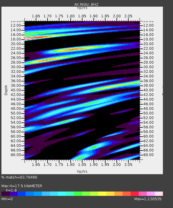
| Estimated Moho Depth: |
17.5 km |
| Estimated Crust Vp/Vs: |
1.60 |
| Assumed Crust Vp: |
6.566 km/s |
| Estimated Crust Vs: |
4.104 km/s |
| Estimated Crust Poisson's Ratio: |
0.18 |
|
| Radial Match: |
83.78498 % |
| Radial Bump: |
400 |
| Transverse Match: |
74.69249 % |
| Transverse Bump: |
400 |
| SOD ConfigId: |
21166931 |
| Insert Time: |
2020-04-24 16:47:44.027 +0000 |
| GWidth: |
2.5 |
| Max Bumps: |
400 |
| Tol: |
0.001 |
|

Signal To Noise
| Channel | StoN | STA | LTA |
| AK:RKAV: :BHZ:20200410T16:55:53.348017Z | 22.53823 | 3.4947407E-6 | 1.5505834E-7 |
| AK:RKAV: :BHN:20200410T16:55:53.348017Z | 9.831834 | 2.0696377E-6 | 2.1050373E-7 |
| AK:RKAV: :BHE:20200410T16:55:53.348017Z | 7.755598 | 1.4114289E-6 | 1.8198841E-7 |
| Arrivals |
| Ps | 1.7 SECOND |
| PpPs | 6.7 SECOND |
| PsPs/PpSs | 8.3 SECOND |


