You are here: Home > Network List > TS - TERRAscope (Southern California Seismic Network) Stations List
> Station SBC Santa Barbara, California, USA > Earthquake Result Viewer
SBC Santa Barbara, California, USA - Earthquake Result Viewer
| Earthquake location: |
Santiago Del Estero Prov., Arg. |
| Earthquake latitude/longitude: |
-26.8/-63.4 |
| Earthquake time(UTC): |
1991/06/23 (174) 21:22:30 GMT |
| Earthquake Depth: |
581 km |
| Earthquake Magnitude: |
6.4 MB, 6.2 UNKNOWN |
| Earthquake Catalog/Contributor: |
WHDF/NEIC |
|
| Network: |
TS TERRAscope (Southern California Seismic Network) |
| Station: |
SBC Santa Barbara, California, USA |
| Lat/Lon: |
34.44 N/119.71 W |
| Elevation: |
90 m |
|
| Distance: |
81.0 deg |
| Az: |
315.869 deg |
| Baz: |
131.158 deg |
| Ray Param: |
0.046148587 |
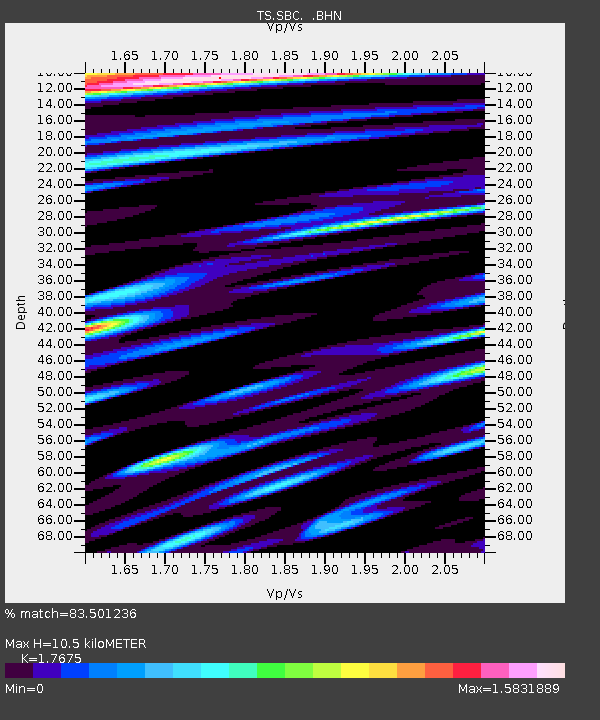
| Estimated Moho Depth: |
10.5 km |
| Estimated Crust Vp/Vs: |
1.77 |
| Assumed Crust Vp: |
6.1 km/s |
| Estimated Crust Vs: |
3.451 km/s |
| Estimated Crust Poisson's Ratio: |
0.26 |
|
| Radial Match: |
83.501236 % |
| Radial Bump: |
400 |
| Transverse Match: |
79.35286 % |
| Transverse Bump: |
400 |
| SOD ConfigId: |
16938 |
| Insert Time: |
2010-02-26 14:46:23.389 +0000 |
| GWidth: |
2.5 |
| Max Bumps: |
400 |
| Tol: |
0.001 |
|
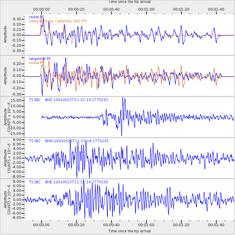
Signal To Noise
| Channel | StoN | STA | LTA |
| TS:SBC: :BHN:19910623T21:33:14.277026Z | 1.3377146 | 8.8004566E-7 | 6.5787253E-7 |
| TS:SBC: :BHE:19910623T21:33:14.277026Z | 0.94697046 | 5.9095805E-7 | 6.2405115E-7 |
| TS:SBC: :BHZ:19910623T21:33:14.277026Z | 1.9925497 | 1.1140222E-6 | 5.5909385E-7 |
| Arrivals |
| Ps | 1.4 SECOND |
| PpPs | 4.7 SECOND |
| PsPs/PpSs | 6.0 SECOND |


