You are here: Home > Network List > KN - Kyrgyz Seismic Telemetry Network Stations List
> Station AML KN.AML > Earthquake Result Viewer
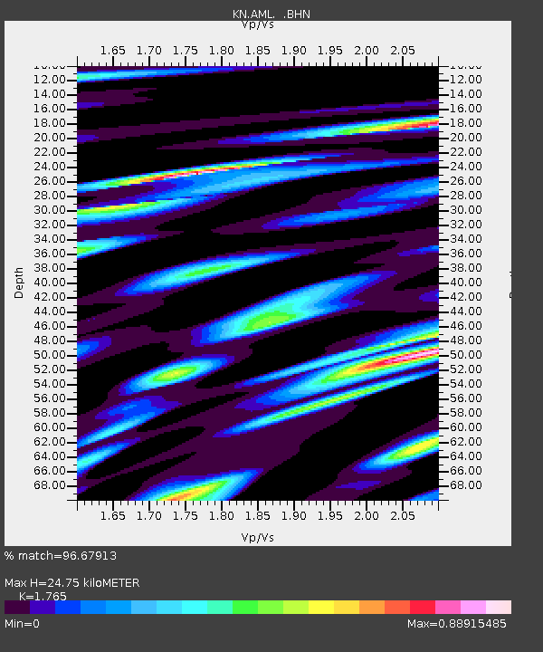
AML KN.AML - Earthquake Result Viewer
| Earthquake location: |
New Ireland Region, P.N.G. |
| Earthquake latitude/longitude: |
-4.5/153.5 |
| Earthquake time(UTC): |
2005/09/09 (252) 07:26:43 GMT |
| Earthquake Depth: |
90 km |
| Earthquake Magnitude: |
6.3 MB, 7.7 MW, 7.5 MW |
| Earthquake Catalog/Contributor: |
WHDF/NEIC |
|
| Network: |
KN Kyrgyz Seismic Telemetry Network |
| Station: |
AML KN.AML |
| Lat/Lon: |
42.13 N/73.69 E |
| Elevation: |
3400 m |
|
| Distance: |
85.5 deg |
| Az: |
312.748 deg |
| Baz: |
100.209 deg |
| Ray Param: |
0.044557557 |
| Estimated Moho Depth: |
24.75 km |
| Estimated Crust Vp/Vs: |
1.76 |
| Assumed Crust Vp: |
6.316 km/s |
| Estimated Crust Vs: |
3.578 km/s |
| Estimated Crust Poisson's Ratio: |
0.26 |
|
| Radial Match: |
96.67913 % |
| Radial Bump: |
400 |
| Transverse Match: |
90.57656 % |
| Transverse Bump: |
400 |
| SOD ConfigId: |
2475 |
| Insert Time: |
2010-03-08 19:06:07.818 +0000 |
| GWidth: |
2.5 |
| Max Bumps: |
400 |
| Tol: |
0.001 |
|

Signal To Noise
| Channel | StoN | STA | LTA |
| KN:AML: :BHN:20050909T07:38:40.349019Z | 4.13766 | 3.8549967E-7 | 9.3168524E-8 |
| KN:AML: :BHE:20050909T07:38:40.349019Z | 12.917007 | 1.2291762E-6 | 9.5159514E-8 |
| KN:AML: :BHZ:20050909T07:38:40.349019Z | 31.348038 | 4.068872E-6 | 1.2979669E-7 |
| Arrivals |
| Ps | 3.1 SECOND |
| PpPs | 11 SECOND |
| PsPs/PpSs | 14 SECOND |


