You are here: Home > Network List > AV - Alaska Volcano Observatory Stations List
> Station ACH Angle Creek Headwaters, Katmai, Alaska > Earthquake Result Viewer
ACH Angle Creek Headwaters, Katmai, Alaska - Earthquake Result Viewer
| Earthquake location: |
Philippine Islands Region |
| Earthquake latitude/longitude: |
20.4/122.1 |
| Earthquake time(UTC): |
2020/04/10 (101) 16:44:55 GMT |
| Earthquake Depth: |
149 km |
| Earthquake Magnitude: |
5.9 mww |
| Earthquake Catalog/Contributor: |
NEIC PDE/us |
|
| Network: |
AV Alaska Volcano Observatory |
| Station: |
ACH Angle Creek Headwaters, Katmai, Alaska |
| Lat/Lon: |
58.21 N/155.33 W |
| Elevation: |
960 m |
|
| Distance: |
69.0 deg |
| Az: |
34.217 deg |
| Baz: |
274.949 deg |
| Ray Param: |
0.05554664 |
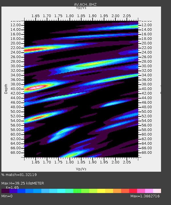
| Estimated Moho Depth: |
39.25 km |
| Estimated Crust Vp/Vs: |
1.65 |
| Assumed Crust Vp: |
6.438 km/s |
| Estimated Crust Vs: |
3.902 km/s |
| Estimated Crust Poisson's Ratio: |
0.21 |
|
| Radial Match: |
81.32119 % |
| Radial Bump: |
388 |
| Transverse Match: |
73.01007 % |
| Transverse Bump: |
329 |
| SOD ConfigId: |
21166931 |
| Insert Time: |
2020-04-24 16:49:07.715 +0000 |
| GWidth: |
2.5 |
| Max Bumps: |
400 |
| Tol: |
0.001 |
|

Signal To Noise
| Channel | StoN | STA | LTA |
| AV:ACH: :BHZ:20200410T16:55:13.867975Z | 22.288898 | 1.4281156E-6 | 6.407296E-8 |
| AV:ACH: :BHN:20200410T16:55:13.867975Z | 7.3934684 | 9.50687E-7 | 1.2858472E-7 |
| AV:ACH: :BHE:20200410T16:55:13.867975Z | 18.764479 | 1.3274918E-6 | 7.074493E-8 |
| Arrivals |
| Ps | 4.1 SECOND |
| PpPs | 16 SECOND |
| PsPs/PpSs | 20 SECOND |


