You are here: Home > Network List > AV - Alaska Volcano Observatory Stations List
> Station ILS Iliamna South, Iliamna Volcano, Alaska > Earthquake Result Viewer
ILS Iliamna South, Iliamna Volcano, Alaska - Earthquake Result Viewer
| Earthquake location: |
Philippine Islands Region |
| Earthquake latitude/longitude: |
20.4/122.1 |
| Earthquake time(UTC): |
2020/04/10 (101) 16:44:55 GMT |
| Earthquake Depth: |
149 km |
| Earthquake Magnitude: |
5.9 mww |
| Earthquake Catalog/Contributor: |
NEIC PDE/us |
|
| Network: |
AV Alaska Volcano Observatory |
| Station: |
ILS Iliamna South, Iliamna Volcano, Alaska |
| Lat/Lon: |
59.96 N/153.07 W |
| Elevation: |
1125 m |
|
| Distance: |
70.0 deg |
| Az: |
32.234 deg |
| Baz: |
276.187 deg |
| Ray Param: |
0.0549081 |
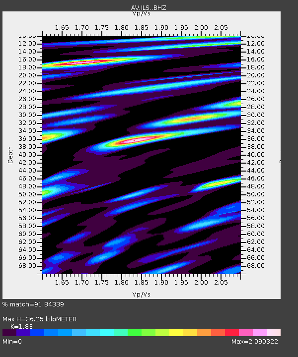
| Estimated Moho Depth: |
36.25 km |
| Estimated Crust Vp/Vs: |
1.83 |
| Assumed Crust Vp: |
5.989 km/s |
| Estimated Crust Vs: |
3.273 km/s |
| Estimated Crust Poisson's Ratio: |
0.29 |
|
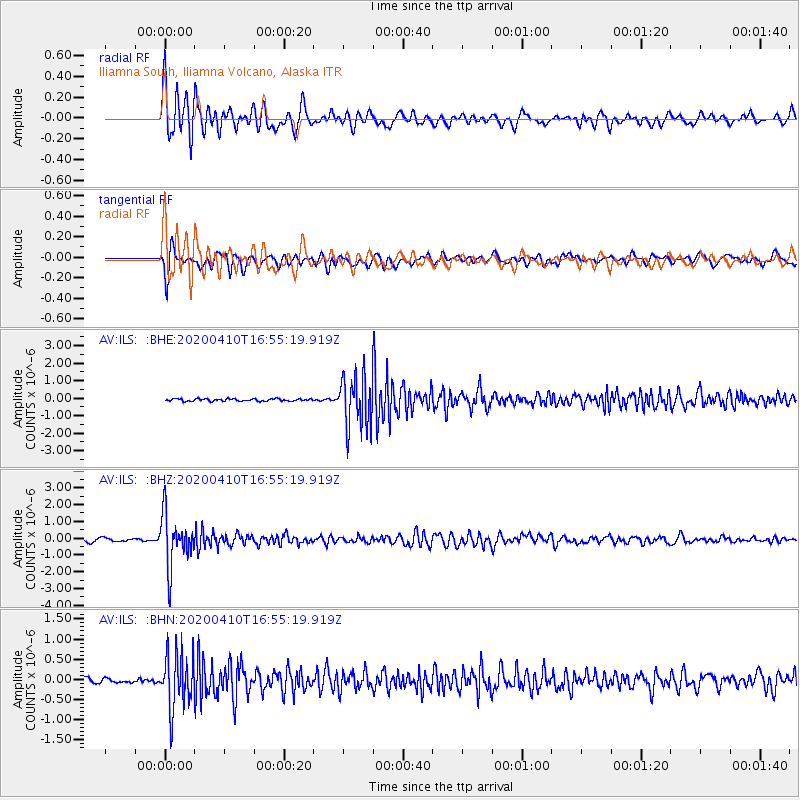
| Radial Match: |
91.84339 % |
| Radial Bump: |
400 |
| Transverse Match: |
88.300026 % |
| Transverse Bump: |
400 |
| SOD ConfigId: |
21166931 |
| Insert Time: |
2020-04-24 16:49:50.420 +0000 |
| GWidth: |
2.5 |
| Max Bumps: |
400 |
| Tol: |
0.001 |
|
Signal To Noise
| Channel | StoN | STA | LTA |
| AV:ILS: :BHZ:20200410T16:55:19.919Z | 17.100475 | 1.5263097E-6 | 8.9255394E-8 |
| AV:ILS: :BHN:20200410T16:55:19.919Z | 9.647727 | 7.010583E-7 | 7.266565E-8 |
| AV:ILS: :BHE:20200410T16:55:19.919Z | 23.029354 | 1.4890704E-6 | 6.465967E-8 |
| Arrivals |
| Ps | 5.2 SECOND |
| PpPs | 17 SECOND |
| PsPs/PpSs | 22 SECOND |


