You are here: Home > Network List > AV - Alaska Volcano Observatory Stations List
> Station ILSW Iliamna Southwest, Iliamna Volcano, Alaska > Earthquake Result Viewer
ILSW Iliamna Southwest, Iliamna Volcano, Alaska - Earthquake Result Viewer

| Earthquake location: |
Philippine Islands Region |
| Earthquake latitude/longitude: |
20.4/122.1 |
| Earthquake time(UTC): |
2020/04/10 (101) 16:44:55 GMT |
| Earthquake Depth: |
149 km |
| Earthquake Magnitude: |
5.9 mww |
| Earthquake Catalog/Contributor: |
NEIC PDE/us |
|
| Network: |
AV Alaska Volcano Observatory |
| Station: |
ILSW Iliamna Southwest, Iliamna Volcano, Alaska |
| Lat/Lon: |
59.98 N/153.14 W |
| Elevation: |
1318 m |
|
| Distance: |
69.9 deg |
| Az: |
32.21 deg |
| Baz: |
276.117 deg |
| Ray Param: |
0.054934233 |
| Estimated Moho Depth: |
38.0 km |
| Estimated Crust Vp/Vs: |
1.66 |
| Assumed Crust Vp: |
5.989 km/s |
| Estimated Crust Vs: |
3.613 km/s |
| Estimated Crust Poisson's Ratio: |
0.21 |
|
| Radial Match: |
83.654785 % |
| Radial Bump: |
400 |
| Transverse Match: |
70.56692 % |
| Transverse Bump: |
400 |
| SOD ConfigId: |
21166931 |
| Insert Time: |
2020-04-24 16:49:50.747 +0000 |
| GWidth: |
2.5 |
| Max Bumps: |
400 |
| Tol: |
0.001 |
|
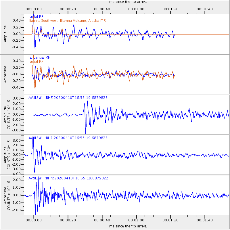
Signal To Noise
| Channel | StoN | STA | LTA |
| AV:ILSW: :BHZ:20200410T16:55:19.687982Z | 22.772692 | 1.9010496E-6 | 8.347936E-8 |
| AV:ILSW: :BHN:20200410T16:55:19.687982Z | 17.064867 | 1.0804415E-6 | 6.331379E-8 |
| AV:ILSW: :BHE:20200410T16:55:19.687982Z | 14.315808 | 1.6603539E-6 | 1.1598045E-7 |
| Arrivals |
| Ps | 4.3 SECOND |
| PpPs | 16 SECOND |
| PsPs/PpSs | 21 SECOND |


