You are here: Home > Network List > AV - Alaska Volcano Observatory Stations List
> Station KABU KABU - Katmai Volcanic Cluster, Alaska > Earthquake Result Viewer
KABU KABU - Katmai Volcanic Cluster, Alaska - Earthquake Result Viewer

| Earthquake location: |
Philippine Islands Region |
| Earthquake latitude/longitude: |
20.4/122.1 |
| Earthquake time(UTC): |
2020/04/10 (101) 16:44:55 GMT |
| Earthquake Depth: |
149 km |
| Earthquake Magnitude: |
5.9 mww |
| Earthquake Catalog/Contributor: |
NEIC PDE/us |
|
| Network: |
AV Alaska Volcano Observatory |
| Station: |
KABU KABU - Katmai Volcanic Cluster, Alaska |
| Lat/Lon: |
58.27 N/155.28 W |
| Elevation: |
1065 m |
|
| Distance: |
69.0 deg |
| Az: |
34.149 deg |
| Baz: |
274.964 deg |
| Ray Param: |
0.055534393 |
| Estimated Moho Depth: |
26.75 km |
| Estimated Crust Vp/Vs: |
2.06 |
| Assumed Crust Vp: |
6.438 km/s |
| Estimated Crust Vs: |
3.122 km/s |
| Estimated Crust Poisson's Ratio: |
0.35 |
|
| Radial Match: |
86.17986 % |
| Radial Bump: |
400 |
| Transverse Match: |
76.99203 % |
| Transverse Bump: |
400 |
| SOD ConfigId: |
21166931 |
| Insert Time: |
2020-04-24 16:49:53.970 +0000 |
| GWidth: |
2.5 |
| Max Bumps: |
400 |
| Tol: |
0.001 |
|
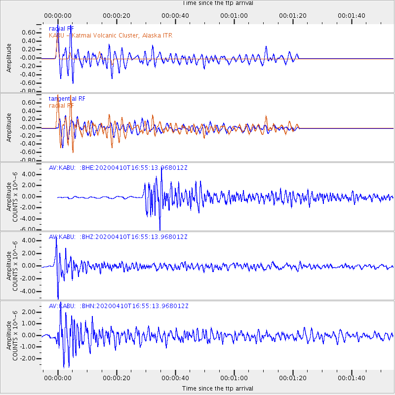
Signal To Noise
| Channel | StoN | STA | LTA |
| AV:KABU: :BHZ:20200410T16:55:13.968012Z | 16.110153 | 2.0422328E-6 | 1.2676682E-7 |
| AV:KABU: :BHN:20200410T16:55:13.968012Z | 16.144827 | 1.3194109E-6 | 8.172345E-8 |
| AV:KABU: :BHE:20200410T16:55:13.968012Z | 18.752808 | 2.2555776E-6 | 1.2027945E-7 |
| Arrivals |
| Ps | 4.6 SECOND |
| PpPs | 12 SECOND |
| PsPs/PpSs | 17 SECOND |


