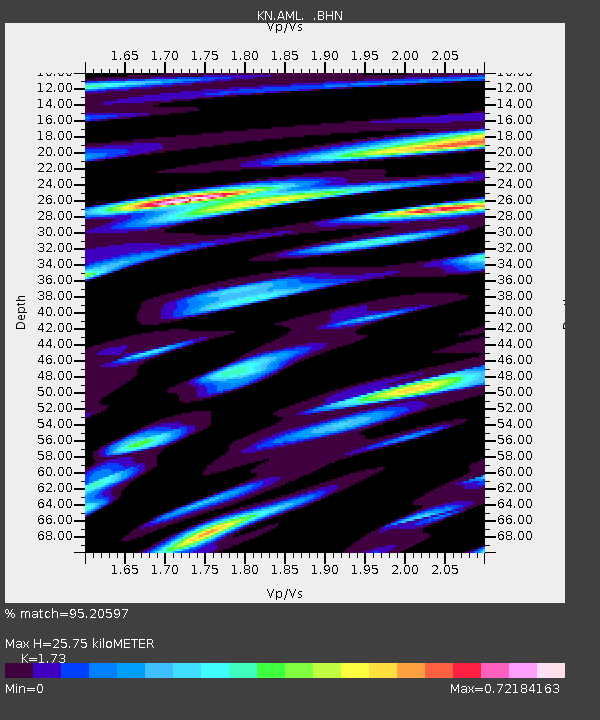
AML KN.AML - Earthquake Result Viewer

Earthquake location: Near North Coast Of Irian Jaya
Earthquake latitude/longitude: -2.4/139.1
Earthquake time(UTC): 2007/12/22 (356) 07:11:09 GMT
Earthquake Depth: 27 km
Earthquake Magnitude: 6.0 MB, 6.1 MS, 6.1 MW, 6.0 ME
Earthquake Catalog/Contributor: WHDF/NEIC
Network: KN Kyrgyz Seismic Telemetry Network
Station: AML KN.AML
Lat/Lon: 42.13 N/73.69 E
Elevation: 3400 m
Distance: 73.6 deg
Az: 315.196 deg
Baz: 108.825 deg
Ray Param: 0.052838672
Estimated Moho Depth: 25.75 km
Estimated Crust Vp/Vs: 1.73
Assumed Crust Vp: 6.316 km/s
Estimated Crust Vs: 3.651 km/s
Estimated Crust Poisson's Ratio: 0.25
Radial Match: 95.20597 %
Radial Bump: 400
Transverse Match: 90.86318 %
Transverse Bump: 400
SOD ConfigId: 2564
Insert Time: 2010-03-08 19:06:32.338 +0000
GWidth: 2.5
Max Bumps: 400
Tol: 0.001

Signal To Noise

ChannelStoNSTALTA
KN:AML: :BHN:20071222T07:22:08.924016Z1.84480451.7892754E-79.6989965E-8
KN:AML: :BHE:20071222T07:22:08.924016Z4.5315942.7198425E-76.001955E-8
KN:AML: :BHZ:20071222T07:22:08.924016Z14.7860047.253346E-74.9055483E-8
Arrivals
Ps3.1 SECOND
PpPs11 SECOND
PsPs/PpSs14 SECOND