You are here: Home > Network List > US - United States National Seismic Network Stations List
> Station DGMT Dagmar, Montana, USA > Earthquake Result Viewer
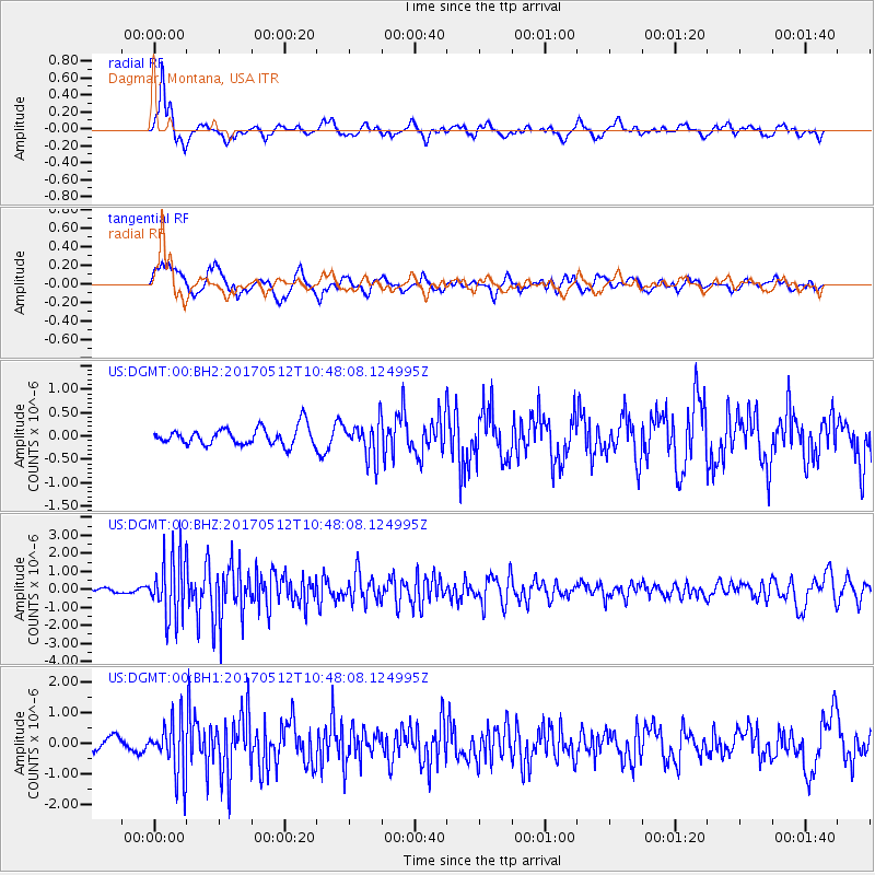
DGMT Dagmar, Montana, USA - Earthquake Result Viewer
*The percent match for this event was below the threshold and hence no stack was calculated.
| Earthquake location: |
Off Coast Of Central America |
| Earthquake latitude/longitude: |
12.9/-90.1 |
| Earthquake time(UTC): |
2017/05/12 (132) 10:41:26 GMT |
| Earthquake Depth: |
10 km |
| Earthquake Magnitude: |
6.2 Mww |
| Earthquake Catalog/Contributor: |
NEIC PDE/us |
|
| Network: |
US United States National Seismic Network |
| Station: |
DGMT Dagmar, Montana, USA |
| Lat/Lon: |
48.47 N/104.20 W |
| Elevation: |
0.0 m |
|
| Distance: |
37.3 deg |
| Az: |
344.457 deg |
| Baz: |
156.884 deg |
| Ray Param: |
$rayparam |
*The percent match for this event was below the threshold and hence was not used in the summary stack. |
|
| Radial Match: |
82.50222 % |
| Radial Bump: |
356 |
| Transverse Match: |
74.2491 % |
| Transverse Bump: |
400 |
| SOD ConfigId: |
2028011 |
| Insert Time: |
2017-05-26 10:49:20.322 +0000 |
| GWidth: |
2.5 |
| Max Bumps: |
400 |
| Tol: |
0.001 |
|
Signal To Noise
| Channel | StoN | STA | LTA |
| US:DGMT:00:BHZ:20170512T10:48:08.124995Z | 10.723581 | 1.7147356E-6 | 1.5990325E-7 |
| US:DGMT:00:BH1:20170512T10:48:08.124995Z | 2.4779377 | 8.966688E-7 | 3.618609E-7 |
| US:DGMT:00:BH2:20170512T10:48:08.124995Z | 2.0573554 | 3.864906E-7 | 1.8785798E-7 |
| Arrivals |
| Ps | |
| PpPs | |
| PsPs/PpSs | |


