You are here: Home > Network List > KN - Kyrgyz Seismic Telemetry Network Stations List
> Station AML KN.AML > Earthquake Result Viewer
AML KN.AML - Earthquake Result Viewer
| Earthquake location: |
Mindanao, Philippines |
| Earthquake latitude/longitude: |
5.9/126.8 |
| Earthquake time(UTC): |
2007/11/17 (321) 15:02:36 GMT |
| Earthquake Depth: |
80 km |
| Earthquake Magnitude: |
5.5 MB, 5.4 MW |
| Earthquake Catalog/Contributor: |
WHDF/NEIC |
|
| Network: |
KN Kyrgyz Seismic Telemetry Network |
| Station: |
AML KN.AML |
| Lat/Lon: |
42.13 N/73.69 E |
| Elevation: |
3400 m |
|
| Distance: |
59.2 deg |
| Az: |
316.121 deg |
| Baz: |
112.043 deg |
| Ray Param: |
0.06213533 |
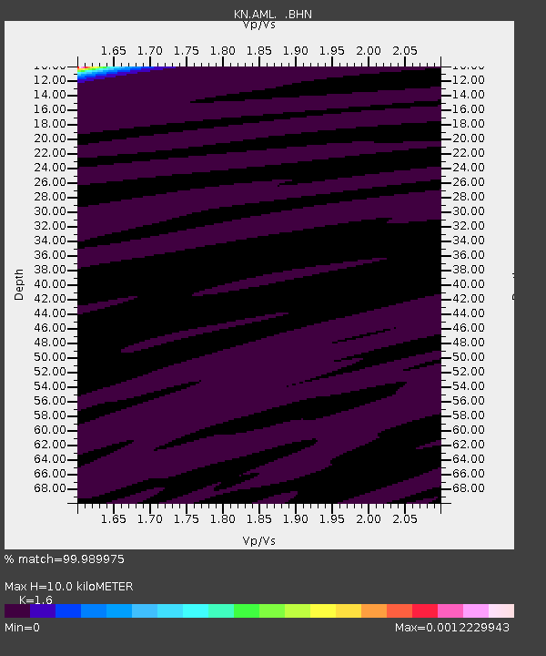
| Estimated Moho Depth: |
10.0 km |
| Estimated Crust Vp/Vs: |
1.60 |
| Assumed Crust Vp: |
6.316 km/s |
| Estimated Crust Vs: |
3.947 km/s |
| Estimated Crust Poisson's Ratio: |
0.18 |
|
| Radial Match: |
99.989975 % |
| Radial Bump: |
3 |
| Transverse Match: |
99.97079 % |
| Transverse Bump: |
4 |
| SOD ConfigId: |
2564 |
| Insert Time: |
2010-03-08 19:06:55.031 +0000 |
| GWidth: |
2.5 |
| Max Bumps: |
400 |
| Tol: |
0.001 |
|

Signal To Noise
| Channel | StoN | STA | LTA |
| KN:AML: :BHN:20071117T15:11:58.099016Z | 2.849822 | 8.9963834E-8 | 3.1568227E-8 |
| KN:AML: :BHE:20071117T15:11:58.099016Z | 0.91798717 | 3.5231764E-7 | 3.8379363E-7 |
| KN:AML: :BHZ:20071117T15:11:58.099016Z | 1.3014979 | 3.378402E-7 | 2.5957794E-7 |
| Arrivals |
| Ps | 1.0 SECOND |
| PpPs | 3.9 SECOND |
| PsPs/PpSs | 4.9 SECOND |


