You are here: Home > Network List > TS - TERRAscope (Southern California Seismic Network) Stations List
> Station SBC Santa Barbara, California, USA > Earthquake Result Viewer
SBC Santa Barbara, California, USA - Earthquake Result Viewer
| Earthquake location: |
Near West Coast Of Colombia |
| Earthquake latitude/longitude: |
4.6/-77.5 |
| Earthquake time(UTC): |
1991/11/19 (323) 22:28:50 GMT |
| Earthquake Depth: |
21 km |
| Earthquake Magnitude: |
6.5 MB, 7.0 MS, 6.4 UNKNOWN |
| Earthquake Catalog/Contributor: |
WHDF/NEIC |
|
| Network: |
TS TERRAscope (Southern California Seismic Network) |
| Station: |
SBC Santa Barbara, California, USA |
| Lat/Lon: |
34.44 N/119.71 W |
| Elevation: |
90 m |
|
| Distance: |
49.1 deg |
| Az: |
312.72 deg |
| Baz: |
117.606 deg |
| Ray Param: |
0.06887786 |
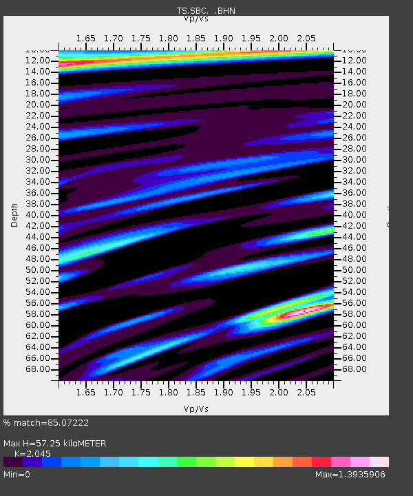
| Estimated Moho Depth: |
57.25 km |
| Estimated Crust Vp/Vs: |
2.05 |
| Assumed Crust Vp: |
6.1 km/s |
| Estimated Crust Vs: |
2.983 km/s |
| Estimated Crust Poisson's Ratio: |
0.34 |
|
| Radial Match: |
85.07222 % |
| Radial Bump: |
400 |
| Transverse Match: |
86.324715 % |
| Transverse Bump: |
400 |
| SOD ConfigId: |
16938 |
| Insert Time: |
2010-02-26 14:46:27.098 +0000 |
| GWidth: |
2.5 |
| Max Bumps: |
400 |
| Tol: |
0.001 |
|
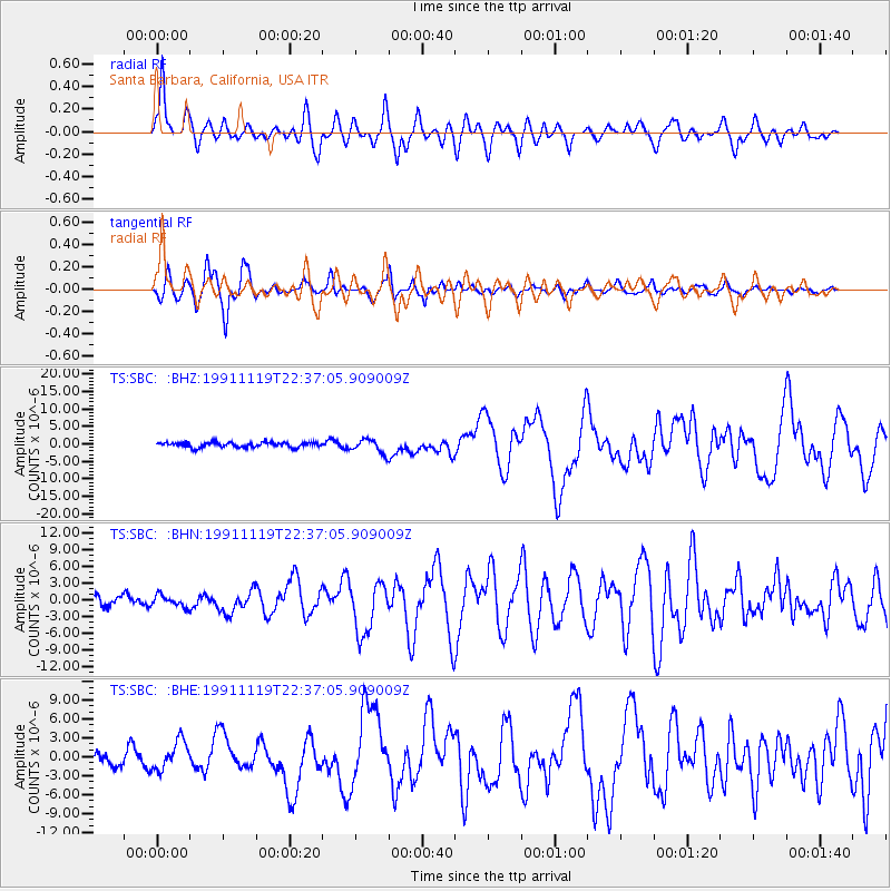
Signal To Noise
| Channel | StoN | STA | LTA |
| TS:SBC: :BHN:19911119T22:37:05.909009Z | 1.0505233 | 1.0694616E-6 | 1.0180275E-6 |
| TS:SBC: :BHE:19911119T22:37:05.909009Z | 1.4238478 | 2.2433019E-6 | 1.5755209E-6 |
| TS:SBC: :BHZ:19911119T22:37:05.909009Z | 2.8318539 | 1.9852957E-6 | 7.0105864E-7 |
| Arrivals |
| Ps | 10 SECOND |
| PpPs | 27 SECOND |
| PsPs/PpSs | 38 SECOND |


