You are here: Home > Network List > CN - Canadian National Seismograph Network Stations List
> Station WSLR Whistler, BC, CA > Earthquake Result Viewer
WSLR Whistler, BC, CA - Earthquake Result Viewer
| Earthquake location: |
Philippine Islands Region |
| Earthquake latitude/longitude: |
20.4/122.1 |
| Earthquake time(UTC): |
2020/04/10 (101) 16:44:55 GMT |
| Earthquake Depth: |
149 km |
| Earthquake Magnitude: |
5.9 mww |
| Earthquake Catalog/Contributor: |
NEIC PDE/us |
|
| Network: |
CN Canadian National Seismograph Network |
| Station: |
WSLR Whistler, BC, CA |
| Lat/Lon: |
50.13 N/122.92 W |
| Elevation: |
907 m |
|
| Distance: |
89.4 deg |
| Az: |
35.701 deg |
| Baz: |
301.751 deg |
| Ray Param: |
0.04173103 |
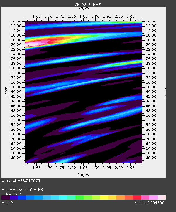
| Estimated Moho Depth: |
20.0 km |
| Estimated Crust Vp/Vs: |
1.62 |
| Assumed Crust Vp: |
6.566 km/s |
| Estimated Crust Vs: |
4.066 km/s |
| Estimated Crust Poisson's Ratio: |
0.19 |
|
| Radial Match: |
83.517975 % |
| Radial Bump: |
400 |
| Transverse Match: |
79.08264 % |
| Transverse Bump: |
400 |
| SOD ConfigId: |
21166931 |
| Insert Time: |
2020-04-24 16:53:55.692 +0000 |
| GWidth: |
2.5 |
| Max Bumps: |
400 |
| Tol: |
0.001 |
|

Signal To Noise
| Channel | StoN | STA | LTA |
| CN:WSLR: :HHZ:20200410T16:57:04.039972Z | 15.882345 | 1.8249476E-6 | 1.1490417E-7 |
| CN:WSLR: :HHN:20200410T16:57:04.039972Z | 8.087354 | 5.895367E-7 | 7.289612E-8 |
| CN:WSLR: :HHE:20200410T16:57:04.039972Z | 6.8574038 | 4.273541E-7 | 6.2320105E-8 |
| Arrivals |
| Ps | 1.9 SECOND |
| PpPs | 7.8 SECOND |
| PsPs/PpSs | 9.7 SECOND |


