You are here: Home > Network List > IU - Global Seismograph Network (GSN - IRIS/USGS) Stations List
> Station PMG Port Moresby, New Guinea > Earthquake Result Viewer
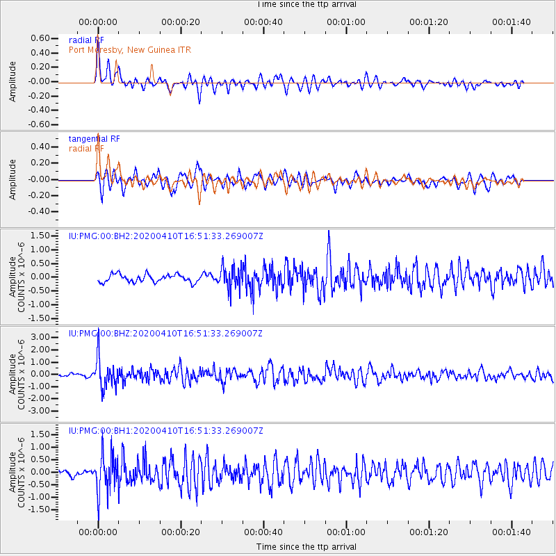
PMG Port Moresby, New Guinea - Earthquake Result Viewer
*The percent match for this event was below the threshold and hence no stack was calculated.
| Earthquake location: |
Philippine Islands Region |
| Earthquake latitude/longitude: |
20.4/122.1 |
| Earthquake time(UTC): |
2020/04/10 (101) 16:44:55 GMT |
| Earthquake Depth: |
149 km |
| Earthquake Magnitude: |
5.9 mww |
| Earthquake Catalog/Contributor: |
NEIC PDE/us |
|
| Network: |
IU Global Seismograph Network (GSN - IRIS/USGS) |
| Station: |
PMG Port Moresby, New Guinea |
| Lat/Lon: |
9.40 S/147.16 E |
| Elevation: |
90 m |
|
| Distance: |
38.5 deg |
| Az: |
137.914 deg |
| Baz: |
320.427 deg |
| Ray Param: |
$rayparam |
*The percent match for this event was below the threshold and hence was not used in the summary stack. |
|
| Radial Match: |
78.56836 % |
| Radial Bump: |
355 |
| Transverse Match: |
76.39677 % |
| Transverse Bump: |
400 |
| SOD ConfigId: |
21166931 |
| Insert Time: |
2020-04-24 16:56:35.286 +0000 |
| GWidth: |
2.5 |
| Max Bumps: |
400 |
| Tol: |
0.001 |
|
Signal To Noise
| Channel | StoN | STA | LTA |
| IU:PMG:00:BHZ:20200410T16:51:33.269007Z | 11.307983 | 1.2445043E-6 | 1.1005538E-7 |
| IU:PMG:00:BH1:20200410T16:51:33.269007Z | 7.945774 | 7.8971135E-7 | 9.938759E-8 |
| IU:PMG:00:BH2:20200410T16:51:33.269007Z | 2.8786697 | 4.086078E-7 | 1.4194327E-7 |
| Arrivals |
| Ps | |
| PpPs | |
| PsPs/PpSs | |


