You are here: Home > Network List > IW - Intermountain West Stations List
> Station PLID Pearl Lake, Idaho, USA > Earthquake Result Viewer
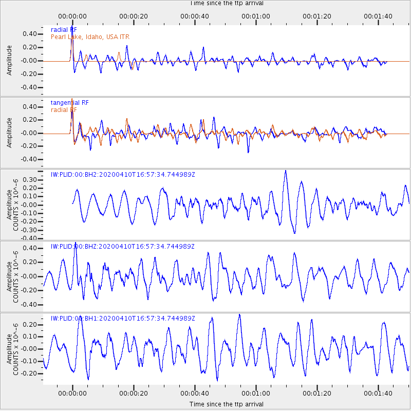
PLID Pearl Lake, Idaho, USA - Earthquake Result Viewer
*The percent match for this event was below the threshold and hence no stack was calculated.
| Earthquake location: |
Philippine Islands Region |
| Earthquake latitude/longitude: |
20.4/122.1 |
| Earthquake time(UTC): |
2020/04/10 (101) 16:44:55 GMT |
| Earthquake Depth: |
149 km |
| Earthquake Magnitude: |
5.9 mww |
| Earthquake Catalog/Contributor: |
NEIC PDE/us |
|
| Network: |
IW Intermountain West |
| Station: |
PLID Pearl Lake, Idaho, USA |
| Lat/Lon: |
45.09 N/116.00 W |
| Elevation: |
2164 m |
|
| Distance: |
96.1 deg |
| Az: |
37.225 deg |
| Baz: |
306.782 deg |
| Ray Param: |
$rayparam |
*The percent match for this event was below the threshold and hence was not used in the summary stack. |
|
| Radial Match: |
59.7394 % |
| Radial Bump: |
400 |
| Transverse Match: |
67.00158 % |
| Transverse Bump: |
400 |
| SOD ConfigId: |
21166931 |
| Insert Time: |
2020-04-24 16:56:46.116 +0000 |
| GWidth: |
2.5 |
| Max Bumps: |
400 |
| Tol: |
0.001 |
|
Signal To Noise
| Channel | StoN | STA | LTA |
| IW:PLID:00:BHZ:20200410T16:57:34.744989Z | 2.7802312 | 2.1187611E-7 | 7.6208096E-8 |
| IW:PLID:00:BH1:20200410T16:57:34.744989Z | 1.8586068 | 1.7068909E-7 | 9.183712E-8 |
| IW:PLID:00:BH2:20200410T16:57:34.744989Z | 1.2259138 | 1.3338853E-7 | 1.0880743E-7 |
| Arrivals |
| Ps | |
| PpPs | |
| PsPs/PpSs | |


