You are here: Home > Network List > KR - Kyrgyz Digital Network Stations List
> Station NRN Naryn, Kyrgyzstan > Earthquake Result Viewer
NRN Naryn, Kyrgyzstan - Earthquake Result Viewer
| Earthquake location: |
Philippine Islands Region |
| Earthquake latitude/longitude: |
20.4/122.1 |
| Earthquake time(UTC): |
2020/04/10 (101) 16:44:55 GMT |
| Earthquake Depth: |
149 km |
| Earthquake Magnitude: |
5.9 mww |
| Earthquake Catalog/Contributor: |
NEIC PDE/us |
|
| Network: |
KR Kyrgyz Digital Network |
| Station: |
NRN Naryn, Kyrgyzstan |
| Lat/Lon: |
41.42 N/75.98 E |
| Elevation: |
2120 m |
|
| Distance: |
44.2 deg |
| Az: |
308.885 deg |
| Baz: |
103.901 deg |
| Ray Param: |
0.07155938 |
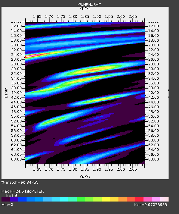
| Estimated Moho Depth: |
24.5 km |
| Estimated Crust Vp/Vs: |
1.60 |
| Assumed Crust Vp: |
6.491 km/s |
| Estimated Crust Vs: |
4.057 km/s |
| Estimated Crust Poisson's Ratio: |
0.18 |
|
| Radial Match: |
90.84755 % |
| Radial Bump: |
400 |
| Transverse Match: |
85.333824 % |
| Transverse Bump: |
400 |
| SOD ConfigId: |
21166931 |
| Insert Time: |
2020-04-24 16:57:18.530 +0000 |
| GWidth: |
2.5 |
| Max Bumps: |
400 |
| Tol: |
0.001 |
|

Signal To Noise
| Channel | StoN | STA | LTA |
| KR:NRN: :BHZ:20200410T16:52:18.980005Z | 25.852606 | 1.1120394E-6 | 4.3014595E-8 |
| KR:NRN: :BHN:20200410T16:52:18.980005Z | 5.792983 | 1.4353151E-7 | 2.4776787E-8 |
| KR:NRN: :BHE:20200410T16:52:18.980005Z | 21.387182 | 6.311372E-7 | 2.9510069E-8 |
| Arrivals |
| Ps | 2.4 SECOND |
| PpPs | 9.1 SECOND |
| PsPs/PpSs | 12 SECOND |


