You are here: Home > Network List > TA - USArray Transportable Network (new EarthScope stations) Stations List
> Station C18K Utukok River, AK, USA > Earthquake Result Viewer
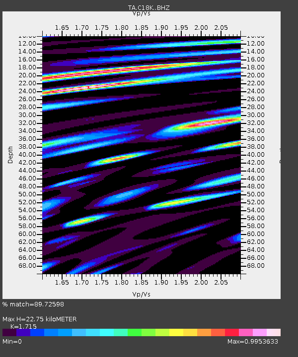
C18K Utukok River, AK, USA - Earthquake Result Viewer
| Earthquake location: |
Philippine Islands Region |
| Earthquake latitude/longitude: |
20.4/122.1 |
| Earthquake time(UTC): |
2020/04/10 (101) 16:44:55 GMT |
| Earthquake Depth: |
149 km |
| Earthquake Magnitude: |
5.9 mww |
| Earthquake Catalog/Contributor: |
NEIC PDE/us |
|
| Network: |
TA USArray Transportable Network (new EarthScope stations) |
| Station: |
C18K Utukok River, AK, USA |
| Lat/Lon: |
68.65 N/161.19 W |
| Elevation: |
845 m |
|
| Distance: |
66.3 deg |
| Az: |
22.905 deg |
| Baz: |
265.37 deg |
| Ray Param: |
0.05728657 |
| Estimated Moho Depth: |
22.75 km |
| Estimated Crust Vp/Vs: |
1.72 |
| Assumed Crust Vp: |
5.906 km/s |
| Estimated Crust Vs: |
3.444 km/s |
| Estimated Crust Poisson's Ratio: |
0.24 |
|
| Radial Match: |
89.72598 % |
| Radial Bump: |
400 |
| Transverse Match: |
88.43786 % |
| Transverse Bump: |
400 |
| SOD ConfigId: |
21166931 |
| Insert Time: |
2020-04-24 16:59:52.356 +0000 |
| GWidth: |
2.5 |
| Max Bumps: |
400 |
| Tol: |
0.001 |
|

Signal To Noise
| Channel | StoN | STA | LTA |
| TA:C18K: :BHZ:20200410T16:54:57.124994Z | 36.879524 | 3.0706574E-6 | 8.326185E-8 |
| TA:C18K: :BHN:20200410T16:54:57.124994Z | 13.856671 | 7.574772E-7 | 5.466516E-8 |
| TA:C18K: :BHE:20200410T16:54:57.124994Z | 22.193438 | 1.0679751E-6 | 4.8121212E-8 |
| Arrivals |
| Ps | 2.9 SECOND |
| PpPs | 10 SECOND |
| PsPs/PpSs | 13 SECOND |


