You are here: Home > Network List > TA - USArray Transportable Network (new EarthScope stations) Stations List
> Station D24K Happy Valley, AK, USA > Earthquake Result Viewer
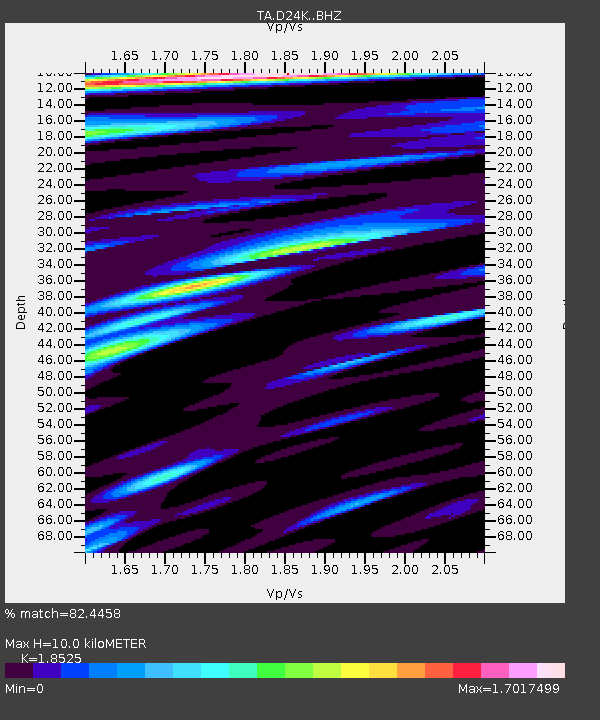
D24K Happy Valley, AK, USA - Earthquake Result Viewer
| Earthquake location: |
Philippine Islands Region |
| Earthquake latitude/longitude: |
20.4/122.1 |
| Earthquake time(UTC): |
2020/04/10 (101) 16:44:55 GMT |
| Earthquake Depth: |
149 km |
| Earthquake Magnitude: |
5.9 mww |
| Earthquake Catalog/Contributor: |
NEIC PDE/us |
|
| Network: |
TA USArray Transportable Network (new EarthScope stations) |
| Station: |
D24K Happy Valley, AK, USA |
| Lat/Lon: |
69.15 N/148.82 W |
| Elevation: |
292 m |
|
| Distance: |
70.8 deg |
| Az: |
22.277 deg |
| Baz: |
276.677 deg |
| Ray Param: |
0.054386966 |
| Estimated Moho Depth: |
10.0 km |
| Estimated Crust Vp/Vs: |
1.85 |
| Assumed Crust Vp: |
6.316 km/s |
| Estimated Crust Vs: |
3.41 km/s |
| Estimated Crust Poisson's Ratio: |
0.29 |
|
| Radial Match: |
82.4458 % |
| Radial Bump: |
400 |
| Transverse Match: |
75.39316 % |
| Transverse Bump: |
400 |
| SOD ConfigId: |
21166931 |
| Insert Time: |
2020-04-24 17:00:09.214 +0000 |
| GWidth: |
2.5 |
| Max Bumps: |
400 |
| Tol: |
0.001 |
|

Signal To Noise
| Channel | StoN | STA | LTA |
| TA:D24K: :BHZ:20200410T16:55:24.72497Z | 31.032778 | 2.8309155E-6 | 9.122339E-8 |
| TA:D24K: :BHN:20200410T16:55:24.72497Z | 3.6934788 | 4.4366774E-7 | 1.2012191E-7 |
| TA:D24K: :BHE:20200410T16:55:24.72497Z | 11.004171 | 8.17019E-7 | 7.4246294E-8 |
| Arrivals |
| Ps | 1.4 SECOND |
| PpPs | 4.4 SECOND |
| PsPs/PpSs | 5.8 SECOND |


