You are here: Home > Network List > TS - TERRAscope (Southern California Seismic Network) Stations List
> Station SBC Santa Barbara, California, USA > Earthquake Result Viewer
SBC Santa Barbara, California, USA - Earthquake Result Viewer
| Earthquake location: |
South Of Panama |
| Earthquake latitude/longitude: |
6.1/-82.4 |
| Earthquake time(UTC): |
1992/06/26 (178) 11:32:30 GMT |
| Earthquake Depth: |
33 km |
| Earthquake Magnitude: |
5.8 MB, 5.4 MS |
| Earthquake Catalog/Contributor: |
WHDF/NEIC |
|
| Network: |
TS TERRAscope (Southern California Seismic Network) |
| Station: |
SBC Santa Barbara, California, USA |
| Lat/Lon: |
34.44 N/119.71 W |
| Elevation: |
90 m |
|
| Distance: |
44.5 deg |
| Az: |
314.352 deg |
| Baz: |
120.647 deg |
| Ray Param: |
0.07180362 |
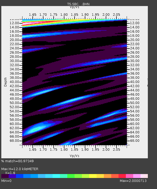
| Estimated Moho Depth: |
12.0 km |
| Estimated Crust Vp/Vs: |
1.60 |
| Assumed Crust Vp: |
6.1 km/s |
| Estimated Crust Vs: |
3.812 km/s |
| Estimated Crust Poisson's Ratio: |
0.18 |
|
| Radial Match: |
80.97349 % |
| Radial Bump: |
395 |
| Transverse Match: |
80.49696 % |
| Transverse Bump: |
400 |
| SOD ConfigId: |
17000 |
| Insert Time: |
2010-02-26 14:46:33.184 +0000 |
| GWidth: |
2.5 |
| Max Bumps: |
400 |
| Tol: |
0.001 |
|
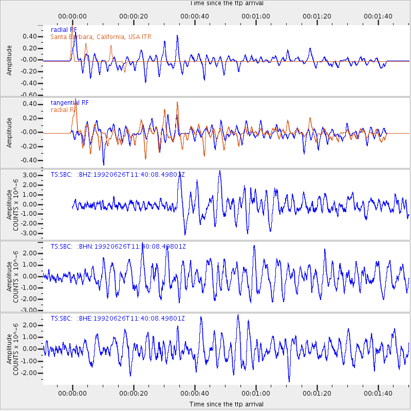
Signal To Noise
| Channel | StoN | STA | LTA |
| TS:SBC: :BHN:19920626T11:40:08.49801Z | 1.0172075 | 3.3109325E-7 | 3.2549232E-7 |
| TS:SBC: :BHE:19920626T11:40:08.49801Z | 1.0810112 | 3.710278E-7 | 3.432229E-7 |
| TS:SBC: :BHZ:19920626T11:40:08.49801Z | 2.608797 | 7.459815E-7 | 2.8594846E-7 |
| Arrivals |
| Ps | 1.3 SECOND |
| PpPs | 4.8 SECOND |
| PsPs/PpSs | 6.1 SECOND |


