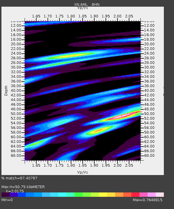
AML KN.AML - Earthquake Result Viewer

Earthquake location: Solomon Islands
Earthquake latitude/longitude: -8.5/157.0
Earthquake time(UTC): 2007/04/01 (091) 20:39:56 GMT
Earthquake Depth: 10 km
Earthquake Magnitude: 6.8 MB, 7.9 MS, 8.1 MW, 7.7 ME
Earthquake Catalog/Contributor: WHDF/NEIC
Network: KN Kyrgyz Seismic Telemetry Network
Station: AML KN.AML
Lat/Lon: 42.13 N/73.69 E
Elevation: 3400 m
Distance: 90.7 deg
Az: 312.362 deg
Baz: 100.679 deg
Ray Param: 0.04165367
Estimated Moho Depth: 50.75 km
Estimated Crust Vp/Vs: 2.02
Assumed Crust Vp: 6.316 km/s
Estimated Crust Vs: 3.13 km/s
Estimated Crust Poisson's Ratio: 0.34
Radial Match: 97.40797 %
Radial Bump: 398
Transverse Match: 94.13432 %
Transverse Bump: 400
SOD ConfigId: 2564
Insert Time: 2010-03-08 19:08:24.441 +0000
GWidth: 2.5
Max Bumps: 400
Tol: 0.001

Signal To Noise

ChannelStoNSTALTA
KN:AML: :BHN:20070401T20:52:27.700007Z1.49697837.313011E-84.885182E-8
KN:AML: :BHE:20070401T20:52:27.700007Z3.16832232.5588014E-78.076202E-8
KN:AML: :BHZ:20070401T20:52:27.700007Z6.3080536.3931355E-71.01348796E-7
Arrivals
Ps8.3 SECOND
PpPs24 SECOND
PsPs/PpSs32 SECOND