You are here: Home > Network List > TA - USArray Transportable Network (new EarthScope stations) Stations List
> Station K15K Wolf Creek Mountain, AK, USA > Earthquake Result Viewer
K15K Wolf Creek Mountain, AK, USA - Earthquake Result Viewer
| Earthquake location: |
Philippine Islands Region |
| Earthquake latitude/longitude: |
20.4/122.1 |
| Earthquake time(UTC): |
2020/04/10 (101) 16:44:55 GMT |
| Earthquake Depth: |
149 km |
| Earthquake Magnitude: |
5.9 mww |
| Earthquake Catalog/Contributor: |
NEIC PDE/us |
|
| Network: |
TA USArray Transportable Network (new EarthScope stations) |
| Station: |
K15K Wolf Creek Mountain, AK, USA |
| Lat/Lon: |
62.29 N/161.53 W |
| Elevation: |
346 m |
|
| Distance: |
65.8 deg |
| Az: |
29.868 deg |
| Baz: |
267.894 deg |
| Ray Param: |
0.05762611 |
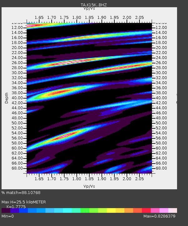
| Estimated Moho Depth: |
25.5 km |
| Estimated Crust Vp/Vs: |
1.78 |
| Assumed Crust Vp: |
6.276 km/s |
| Estimated Crust Vs: |
3.531 km/s |
| Estimated Crust Poisson's Ratio: |
0.27 |
|
| Radial Match: |
88.10768 % |
| Radial Bump: |
400 |
| Transverse Match: |
83.00818 % |
| Transverse Bump: |
400 |
| SOD ConfigId: |
21166931 |
| Insert Time: |
2020-04-24 17:01:36.622 +0000 |
| GWidth: |
2.5 |
| Max Bumps: |
400 |
| Tol: |
0.001 |
|

Signal To Noise
| Channel | StoN | STA | LTA |
| TA:K15K: :BHZ:20200410T16:54:53.825006Z | 19.785793 | 2.6174641E-6 | 1.3229008E-7 |
| TA:K15K: :BHN:20200410T16:54:53.825006Z | 3.045314 | 3.6712726E-7 | 1.2055482E-7 |
| TA:K15K: :BHE:20200410T16:54:53.825006Z | 6.1781716 | 1.0699035E-6 | 1.731748E-7 |
| Arrivals |
| Ps | 3.3 SECOND |
| PpPs | 11 SECOND |
| PsPs/PpSs | 14 SECOND |


