You are here: Home > Network List > TA - USArray Transportable Network (new EarthScope stations) Stations List
> Station L16K Owhat River, AK, USA > Earthquake Result Viewer
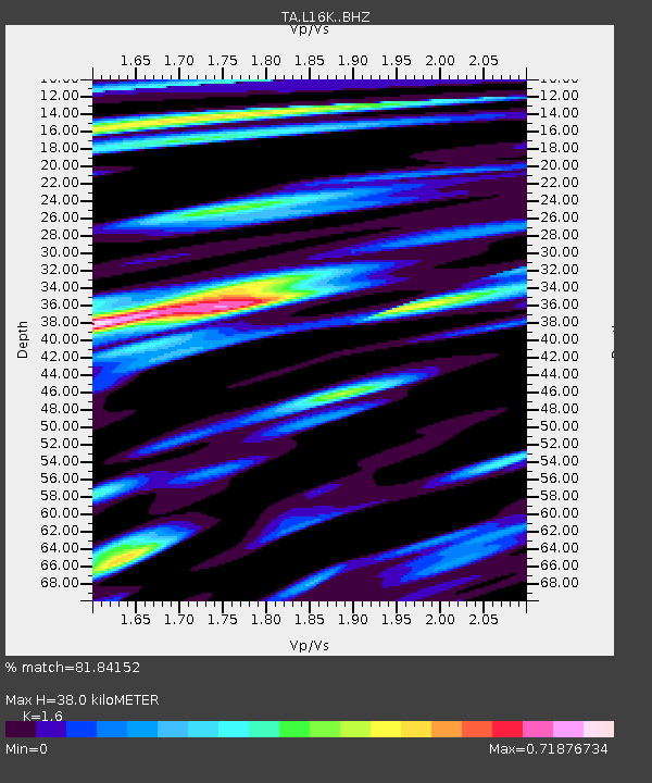
L16K Owhat River, AK, USA - Earthquake Result Viewer
| Earthquake location: |
Philippine Islands Region |
| Earthquake latitude/longitude: |
20.4/122.1 |
| Earthquake time(UTC): |
2020/04/10 (101) 16:44:55 GMT |
| Earthquake Depth: |
149 km |
| Earthquake Magnitude: |
5.9 mww |
| Earthquake Catalog/Contributor: |
NEIC PDE/us |
|
| Network: |
TA USArray Transportable Network (new EarthScope stations) |
| Station: |
L16K Owhat River, AK, USA |
| Lat/Lon: |
61.71 N/159.47 W |
| Elevation: |
227 m |
|
| Distance: |
66.7 deg |
| Az: |
30.527 deg |
| Baz: |
269.972 deg |
| Ray Param: |
0.05700898 |
| Estimated Moho Depth: |
38.0 km |
| Estimated Crust Vp/Vs: |
1.60 |
| Assumed Crust Vp: |
6.276 km/s |
| Estimated Crust Vs: |
3.922 km/s |
| Estimated Crust Poisson's Ratio: |
0.18 |
|
| Radial Match: |
81.84152 % |
| Radial Bump: |
400 |
| Transverse Match: |
84.184105 % |
| Transverse Bump: |
400 |
| SOD ConfigId: |
21166931 |
| Insert Time: |
2020-04-24 17:01:43.245 +0000 |
| GWidth: |
2.5 |
| Max Bumps: |
400 |
| Tol: |
0.001 |
|

Signal To Noise
| Channel | StoN | STA | LTA |
| TA:L16K: :BHZ:20200410T16:54:59.924982Z | 16.751986 | 2.4123656E-6 | 1.4400476E-7 |
| TA:L16K: :BHN:20200410T16:54:59.924982Z | 3.8019288 | 4.3855547E-7 | 1.15350794E-7 |
| TA:L16K: :BHE:20200410T16:54:59.924982Z | 7.377959 | 1.2901073E-6 | 1.7485965E-7 |
| Arrivals |
| Ps | 3.8 SECOND |
| PpPs | 15 SECOND |
| PsPs/PpSs | 19 SECOND |


