You are here: Home > Network List > US - United States National Seismic Network Stations List
> Station EGMT Eagleton, Montana, USA > Earthquake Result Viewer
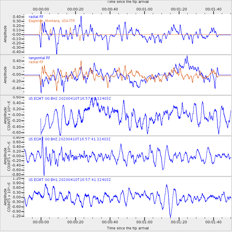
EGMT Eagleton, Montana, USA - Earthquake Result Viewer
*The percent match for this event was below the threshold and hence no stack was calculated.
| Earthquake location: |
Philippine Islands Region |
| Earthquake latitude/longitude: |
20.4/122.1 |
| Earthquake time(UTC): |
2020/04/10 (101) 16:44:55 GMT |
| Earthquake Depth: |
149 km |
| Earthquake Magnitude: |
5.9 mww |
| Earthquake Catalog/Contributor: |
NEIC PDE/us |
|
| Network: |
US United States National Seismic Network |
| Station: |
EGMT Eagleton, Montana, USA |
| Lat/Lon: |
48.02 N/109.75 W |
| Elevation: |
1055 m |
|
| Distance: |
97.6 deg |
| Az: |
32.189 deg |
| Baz: |
311.904 deg |
| Ray Param: |
$rayparam |
*The percent match for this event was below the threshold and hence was not used in the summary stack. |
|
| Radial Match: |
57.71763 % |
| Radial Bump: |
400 |
| Transverse Match: |
35.83454 % |
| Transverse Bump: |
400 |
| SOD ConfigId: |
21166931 |
| Insert Time: |
2020-04-24 17:03:38.060 +0000 |
| GWidth: |
2.5 |
| Max Bumps: |
400 |
| Tol: |
0.001 |
|
Signal To Noise
| Channel | StoN | STA | LTA |
| US:EGMT:00:BHZ:20200410T16:57:41.32403Z | 3.0964954 | 3.6898885E-7 | 1.1916338E-7 |
| US:EGMT:00:BH1:20200410T16:57:41.32403Z | 2.4045634 | 5.9363254E-7 | 2.4687748E-7 |
| US:EGMT:00:BH2:20200410T16:57:41.32403Z | 2.3779566 | 5.7684923E-7 | 2.425819E-7 |
| Arrivals |
| Ps | |
| PpPs | |
| PsPs/PpSs | |


